|
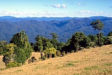
| View from Dorrigo
Mountain looking down the Bellinger Valley
|
Dorrigo
Interesting service town on the edge of the Dorrigo
Plateau.
Located 576 km north of Sydney via the Pacific Highway and
730 m above sea level, Dorrigo sits near the edge of the New
England escarpment and is only a few kilometres from the
steep mountain road which descends into the Bellinger
Valley. It is a pleasant and unassuming country town
servicing the rich agricultural lands which surround it.
Before European settlement the Dorrigo area was inhabited
by the Kumbangerie (sometimes written 'Gumbaynggir' and 'Gumbaingiir
') Aborigines. It was the western extremity of an area which
was bounded by Woolgoolga to the north and Nambucca Heads to
the south.
It is widely accepted that the first European into the
Dorrigo was an escaped convict named Richard Craig. Craig
lived with the local Aborigines and, pursuing their
hunter-gatherer lifestyle, wandered between the coast and
the Dorrigo plateau throughout the year.
The first official European in the district was Land
Commissioner Oakes who sited the mouth of the Bellinger
River on the 3rd of August 1840. By 1841 timber cutters had
entered the Bellinger River searching for red cedar. They
set up camps and moved from one stand of trees to the next.
It was not until the 1860s that permanent settlement
occurred in the district.
Over the years there has been some truly wonderful
controversy about the naming of Dorrigo. For decades the
official version was "At this time Major Edward Parke
explored the Dorrigo Plateau planning to settle there. Major
Parke had fought in the Peninsula Wars under a Spanish
General named Don Dorrigo. He decided to honour this Spanish
General by naming the eastern section of the plateau
'Dorrigo'."
Some sources disagreed with this explanation suggesting
that the name 'Dorrigo' was an abbreviation of 'Dondorrigo'
which was said to have been a local Aboriginal word for the
stringy bark gum tree.
Then, in 2002, a group known as the Dorrigo Plateau
Walking Together Group issued a firm press release insisting
"We note on your Web Page that you make reference to a
Spanish General by the name of Don Dorrigo as the antecedent
for the naming of present day Dorrigo.
"For the sake of accuracy and consistency this
information needs to be corrected.
The NSW Geographical Names Register records that the name
has its antecedence in the Gumbaingiir language, the name of
the indigenous people upon whose land Dorrigo stands, and it
means 'Stringy Bark' (Dundurriga).
"Extensive research has also been conducted with the
Spanish Military Archives in Madrid re "General Don Dorrigo"
and they have confirmed that no such person ever existed.
"As a gesture of reconciliation and sign of respect to
the local Gumbaingiir People you are invited to delete any
reference to 'General Don Dorrigo' and source your
information regarding the origins of the name Dorrigo from
The Geographical Names Register."
Somehow this story stands as a wonderful symbol to
Australian history. How did the story of the Spanish General
ever get started? How could everyone have got it so wrong
for such a long time? Are we so careless with our history
that we would allow such a story to be perpetuated?
Anyway, to continue: Throughout the 1860s people settled
on the Dorrigo Plateau. The cost of settlement was ten
shillings a year for 40 acres and this attracted people
eager to exploit both the wool and cattle prospects of the
land and the rich stands of rosewood, silky oak, cedar,
marble wood and Arctic beech.
By 1865 a track had been constructed from Dorrigo down
the mountain to the Bellinger valley. This ensured access to
the coast. Up to this time it had taken Dorrigo settlers up
to six months to make the return trip to the coast.
The reputation of the Dorrigo Plateau as a place of great
richness and fertility had spread so that by the early years
of the twentieth century the area was being subdivided and
hundreds of people were moving to the district. After the
Great War farms were made available to soldier settlers.
With few exceptions these farmers converted the area into a
rich and productive dairy produce district. Cream was sent
to Bellingen and then on to Brisbane and Sydney by sea. By
1906 Dorrigo had its own butter factory. By 1922 it had a
bacon factory and by the 1930s there was considerable potato
growing in the rich local soils.
Today Dorrigo is a quiet country town. Although it still
exists, the timber industry has declined in importance.
Dairying is still important. The area around the town is
particularly attractive. There are a number of interesting
waterfalls and bushwalks as well as numerous outstanding
views across the Bellinger Valley.
Things to see:
Dorrigo Steam Railway and Museum
Located in Tallowood Street to the west of Dorrigo, this
privately owned company claims to have the largest
collection of railway rolling stock in the Southern
Hemisphere. This probably is a reasonable claim as, at this
point in time, it has 55 locomotives, 280 carriages and
wagons, 13 railmotors and a Silver City Comet set. It is not
yet opened to the general public but if you drive down
Tallowood Street you get a good idea of the vast amount of
equipment which has been accumulated by this unusual museum.
There is also a plan to reopen 70 km of branch line so that
some of the rolling stock can be used to provide round trips
and day trips for visitors. All enquiries should be directed
to (02) 6657 2176.
|
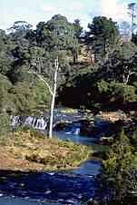
| Dangar Falls tumble into
a cool valley near Dorrigo |
Dangar Falls
Located 2 km north of the town centre, these small and
pretty falls are well worth a visit. There is an attractive
picnic spot which offers excellent vantage points. It is
possible to get down to the banks and walk along the river
below the falls.
Dorrigo National Park
The obvious starting point for any exploration of the
Dorrigo National Park is the Dorrigo Rainforest Centre which
is situated 2 km east of Dorrigo near the top of the
escarpment. The Centre has experienced staff who will not
only explain the flora and fauna of the rainforest but also
provide detailed information on the walks available. The
park is approximately 8 000 hectares of rainforest and
incorporates subtropical rainforest, warm and cool temperate
rainforests and dry rainforest. In the National Park are
impressive stands of sassafras, red cedar, coachwood and
yellow carabeen. There are also over 60 species of bird
including the satin bower-bird, the rufus scrub bird, the
brush turkey and the lyrebird.
Griffiths' Lookout
Located on the edge of the escarpment and offering
outstanding views of the Bellinger Valley, Griffiths'
Lookout can be accessed by turning into Maynard Plains Road
off the main Dorrigo-Bellingen Road near the Lookout Motor
Inn. You turn south and the lookout is a few kilometres
away. On a clear day it is possible to see from this vantage
point to the Pacific Ocean. It is one of the most impressive
lookouts on the eastern coast of Australia.
Ebor Falls
While in the area it is well worth visiting the Ebor Falls
where the Guy Fawkes River drops 115 m over columned basalt
rock. There are toilets, barbecues, tables and running water
and three viewing platforms with sweeping views of the falls
and the Macleay Valley.
New England National Park
The New England National Park, located between Armidale and
Dorrigo, is a world heritage listed wilderness area of
varying habitats reflecting dramatic differences of
altitude. Ecosystems range from snow gum woodland and
Antarctic beech rainforest to subtropical rainforest,
including wet and dry eucalypt forest, subalpine heath and
wetlands. There are 500 plant species (the NPWS have two
brochures on that subject), large numbers of mammals and
reptiles and a significant bird population. Clearly marked
bushwalks lead through mossy beech forests and fern gullies.
Near the park entrance is the Thungatti Camping Area
where there are picnic, barbecue and toilet facilities. On
its eastern edge is a small pocket of rainforest with a
shallow creek. The Tea Tree Falls Walk commences here. This
is a 40-minute stroll through a variety of plant communities
(see NPWS brochure).
The roads continues on past Berarngutta Picnic Area to
Point Lookout, situated 1562 m above sea-level from whence
there are spectacular views down over the almost vertical
escarpment into the Bellinger River Valley and beyond to the
ocean. A short wheelchair-friendly track leads from the car
park. There is a picnic shelter at Point Lookout with an
open fireplace.
The track leads from Point Lookout past Eagle's Nest
Lookout and Banksia Point. At Eagle's Nest Lookout a 3-km
walking track leads along a high country trail, dipping for
a while into cool Antarctic Beech forest.
The 6.4-km circular Lyrebird Nature Walk commences at
Banksia Point, 800 m south of Point Lookout. It leads deep
into rainforest past Weeping Rock, a large sheer
moss-covered cliff face that towers overhead. There are
cabins at Banksia Point. The Chalet has accommodation for up
to six people.
Tom's Cabin is also available for bushwalkers, one km
west of Point Lookout and 5 km from the park entrance. It
has two bedrooms with four bunks apiece. For cabin bookings
tel: (02) 6657 2309. Bush camping is permitted if prior
notification is given. You may wish to purchase provisions
at Ebor. Another option is Little Styx River Cabins. They
offer guided fly fishing safaris and bushwalking, tel: (02)
6775 9166.
The road to Point Lookout passes Styx River Forest Way on
the right ( see previous entry) which leads past camping and
picnic areas and Beech Lookout in Styx River National Park.
Cathedral Rock National Park
5.4 km north-east of the Point Lookout Rd, along Waterfall
Way, is a left turn into Round Mountain Road which will take
you into Cathedral Rocks National Park. Characterised by
large granite outcrops it is an ideal spot for exploring and
climbing. Bushwalkers are rewarded with some excellent
views. The landforms, vegetation and temperatures are quite
different to those experienced in New England National Park.
There are easily accessible wetlands, gully rainforest, wet
and dry eucalypt and wet heath. Wallabies and kangaroos tend
to congregate around the marshlands at dusk. There are also
plenty of wildflowers in summer and birdwatchers will find
the park rewarding.
After 7 km the Round Mountain Road leads to the Barokee
Rest Area and continues on for another kilometre to Round
Mountain (1583 m), the highest point of the New England
Tablelands. The Barokee Rest Area is in the middle section
of the park. From here there is an easy, 5.8-km loop track
to and around Cathedral Rock. There is an additional 400-m
spur track which leads to the top of the rock from whence
the views are outstanding, though the rocks can be slippery
and the track potentially dangerous.
Another possibility is to continue on past Cathedral Rock
to Native Dog River Rest Area (10.4 km, one-way) in the
northern section of the park. It can also be reached by
turning left (west) off Waterfall Way into the Guyra Rd, 10
km beyond the Point Lookout turnoff. It is 8 km along the
Guyra Rd to the Native Dog turnoff. Several walks commence
from here - the Warrigal Track (1 km), and that to Woolpack
Rocks (7.4 km return). It is possible to continue south to
Barokee Rest Area (10.4 km, one-way).
Wollomombi Falls
On the road between Dorrigo and Armidale, and 40 km east of
Armidale, along a signposted side road which heads off
Waterfall Way, are the sensational Wollomombi Falls,
Australia's longest single drop falls where the Wollomombi
River plummets 220 m over the cliff to the gorge below
(after local rains) with Chandler Falls doing likewise
nearby. Situated at 1160 m above sea-level there are gorge
rim walks (including a wheelchair track) which take you to
two outstanding lookouts, and a track, for the fit, that
takes you down the gorge to the Chandler River where you can
swim if the weather is apposite. The latter is hard-going (5
hours return).

Broadwalk
Business Brokers
Broadwalk Business
Brokers specialise in General Businesses for Sale, Caravan Parks for
Sale, Motels for Sale, Management Rights & Resorts for Sale, Farms for
Sale, Hotels for sale,Commercial & Industrial Properties for Sale.
Phone:
1300 136 559
Email:
enquiries@broadwalkbusinessbrokers.com.au
AUSTRALIAN BUSINESSES FOR SALE
COFFS HARBOUR BUSINESS BROKERS
BROADWALK BUSINESS BROKERS
GOLD COAST BUSINESSES FOR SALE
BRISBANE BUSINESSES FOR SALE
SYDNEY BUSINESSES FOR SALE
CARAVAN PARKS FOR SALE
BUSINESSES FOR SALE
MOTELS
FOR SALE
HOTELS
FOR SALE
Disclaimer
We advise prospective purchasers that we take no
responsibility for the accuracy of any information in the business
provided by vendors or their professional advisers and that they should
make their own enquiries as to the accuracy of this information,
including obtaining independent legal and/or accounting advice
Dorrigo