|
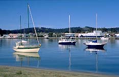
| Looking across the Clyde
River towards the centre of Batemans Bay
|
Batemans Bay
Attractive and substantial service town and fishing port.
Located 279 km south of Sydney via the Princes Highway,
Batemans Bay, at the mouth of the Clyde River, is both a
tourist and retirement resort and a service and commercial
centre for the local sawmilling, wattlebark production,
dairying, cattle-rearing, agriculture, fishing and
oyster-farming industries.
Various sources have cited several Aboriginal groups in
the general vicinity prior to white settlement, these being
the Walbanga, Murrinjari and Bergalia tribes.
The bay was sighted by Captain Cook from the Endeavour on
April 22, 1770. He named it after Nathaniel Bateman, his
superior on the Northumberland which was engaged in a survey
of the coasts of Nova Scotia and Newfoundland. Cook
considered the bay too open to easterly winds to be of much
practical use.
The first Europeans to explore the area were the
survivors from the wreck of the Sydney Cove who reached the
banks of a river, thought to have been the Clyde, on April
16, 1797. Nine of them became the first Europeans to die in
the Batemans Bay area. The remainder crossed the river by a
canoe they found nearby the next day. Only three survived
the difficult journey to Sydney.
George Bass was prompted by the survivors' reports to
venture south and on December 14, 1797, he entered Batemans
Bay. He observed signs of severe drought and reiterated
Cook's view that it was too exposed to function as a port.
The bay was regularly visited during the 1820s and 1830s.
Timber cutters and fishermen were known to be in the
district at the time but there was little settlement,
despite a land sale in 1841.
In 1853 James McCauley, a pioneer settler, piloted the
first steamer up the Clyde River to Nelligen. The township
was gazetted in 1854 and a major road from Nelligen to the
goldfields at Braidwood was completed in 1856.
A township was laid out at Batemans Bay in April 1859.
The postal service commenced operations that year though an
official building was not erected until 1894.
Shipbuilding and oyster farming were established around
1860. Limeburners operated on the coastal estuaries for some
years, burning live oysters for the oxide.
A timber mill was opened at Batemans Bay by Francis Guy
in 1868. In fact the timber trade remained the backbone of
local industry throughout the century with steamers carrying
milled timber to Sydney twice a week or more. Being almost
entirely dependent upon the Sydney building trade the locals
were hit hard by downturns, with mills closing, opening,
moving and burning down with some regularity. Schools were
frequently located near the timber mills and dependent upon
their fate. Children often had to walk miles in flourbag
clothes to attend half-week schooling in small, bark-roofed
slab huts. Apparently baked or stewed koala was not an
uncommon dish during times of economic hardship.
A provisional school opened at Batemans Bay in 1869, with
the population of the district recorded at around 60. It was
declared a public school in 1872.
In 1871 a ferry service was established across the Clyde
at the township of Batemans Bay. It drew some of the trade
away from Nelligen, the major centre in the area at that
time.
A police station was built in 1876, an Anglican church in
the early 1880s (services previously being held in makeshift
premises) and a two-storey courthouse and police residence
in 1885 where the Clyde River Lodge now stands at 3 Clyde
St. It burned down in 1903 and was replaced by another at
the corner of Beach Rd and Orient St in 1905.
In 1892, the year gold was discovered at Batemans Bay,
the population of the township was still only 200, with the
same number at Mogo and some 500 at Nelligen. It is only in
recent times that the numbers have swollen considerably,
from 450 in 1934 to 8320 today. The town was connected to
Nowra by a coach service in 1899. Electricity arrived in the
late 1940s and a bridge was finally built across the Clyde
to replace the ferry service in 1956.
Things to see:
Clyde River and Batemans Bay Historical Society Museum
The Clyde River and Batemans Bay Historical Society Museum
has information on local history as well as an interesting
collection of artefacts and photographs. It is open
Thursdays and Saturdays from 1.00 pm - 4.00 pm (02 4472
8993) and can be found off Beach Road. Turn right just
before the R.S.L. Club and the museum is located adjacent
the new community centre.
Birdland Animal Park
Birdland Animal Park is at 55 Beach Road, on the left just
past the Rugby Union field. It features a number of animals,
including wombats and snakes - both being brought out at
11.30 am and 2.30 pm each day for public handling - an
animal nursery, duck ponds, waterfalls and rides on the
Birdsville Express train through eight acres of parkland. It
is open 9-5 daily and the admission is currently $8 for
adults, $5 for children and $7 for concessions.
Walks around Batemans Bay
Within Batemans Bay take a short walk from the intersection
of the Princes Highway and Beach Road along Beach Road,
turning left at the traffic lights and walking through the
shops to the boatshed. Follow the riverbank under the bridge
and continue to Smoke Point.
For another short and pleasant stroll, cross the bridge,
turn left towards Jamesons on the Pier Restaurant and follow
it to Old Punt Road. Continue along this route then take the
second left into Penthouse Place. At the top of this road is
Folders Hill Lookout. It is a reasonably steep climb but the
reward is excellent views of the Bay.
Alternatively you can follow Beach Road south for about
2.5 km then turn left into Hanging Rock Place and Corrigans
Beach. At the boat ramp continue south along the beach
another 2.5 km to Batehaven. This is an easy, flat route
which takes in some pleasant scenery.
The area around Smugglers Rocks and Smugglers Cove is
worth visiting. Start from Denhams Beach, Surf Beach or
Wimbie Beach at the southern end of town. At the end of
Wimbie is a reserve and a track leading around the headland
to a rocky area.
Cruises on the Clyde River
Those wishing to take a cruise along the Clyde River can
choose from the Clyde Princess (02 4478 1005) or the Merinda
(02 4472 4052) which operate every day. Boats can be hired
from numerous businesses in town and there is a ramp at the
marina.
Lookouts and Vantage Points
Batemans Bay is a good central point for scenic drives,
camping and lookouts. Batemans Bay is surrounded by state
forests - the Boyne, Benandrah, Mogo, Kioloa, Bolaro and
Buckenbowra - and by Murramarang National Park. For detailed
information on the attractions at Murramarang see the entry
on Durras.
1. Holme's Rotary Lookout
The Holme's Rotary Lookout, situated within the Benandrah
State Forest, is 5 km west of Batemans Bay on a signposted
road that departs the Kings Highway.
2. Big Bit Lookout
The Big Bit Lookout lies further north. Drive up the Princes
Highway 1.2 km past the Durras turnoff and head west along
Old Nelligen Road. 2.6 km along this one-laned dirt road you
will come to an intersection. Turn right onto Lookout Road
then take the first right into Big Bit Road (watch for the
small yellow sign). Climb up this hill for 1 km to the
summit. To return to the highway simply continue east along
Big Bit Road.
3. Round Hill Fire Tower Lookout
The Round Hill Fire Tower Lookout lies just 2 km south of
Batemans Bay on the Princes Highway. The walk is only 1.5 km
but you can drive to the top if you prefer. All three of the
above vantage points offer spectacular views over the
surrounding forest and out to the coast.
4. Observation Head
Within the town itself Observation Point is located off
Observation Ave on Observation Head, at the southern end of
Corrigans Beach. There are fine views of Batemans Bay, south
to Malua Bay and across to Long Beach and North Head.
5. Folders Hill Lookout
Folders Hill Lookout is situated near the bridge, on the
northern bank of the Clyde. If you are coming from Sydney,
turn off the Princes Highway just before you reach the
bridge and, instead of taking the first right into the Kings
Highway, take the second into Penthouse Place and the
lookout is at its terminus.
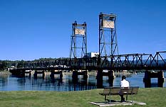
|
| The bridge across the
Clyde River |
Driving in the Area
The beautiful trip south along the coast road through
Broulee to Moruya is delightful.
The drive along the Kings Highway through
Nelligen, past Clyde Mountain, and on to Braidwood is
also attractive.
An alternative is to take a trip through the forest,
heading east off the highway into Pebbly Beach Forest Road
about 17 km north of Batemans Bay and 2 km north of East
Lynne. Follow it through the Kioloa State Forest to Pebbly
Beach at the coast in the Murramarang National Park. From
here wind back west along Mt Agony Road towards the highway.
Part of the way along this route an unsealed tertiary road
appears to the left which will take you back out to the
coast at a point further south (Depot Beach) and from here
you can continue south to Durras North.
If you are driving north towards Ulladulla you may wish
to take the detour along the Old Princes Highway, which
branches off to the west from the present highway about 2 km
north of the Mt Agony Road turnoff. There are three picnic
sites and a number of streams ideal for fishing along this
18-km stretch of road.
Ingolds Knob Lookout lies at the northern end of the
road, which rejoins the highway at Termeil.
A detour from the detour can be made by taking the first
gravel road on the left (Berkshed Road) and heading out to
Shallow Crossing on the banks of the Clyde River. A concrete
causeway crosses the river here. The Crossing is impassable
after heavy rains or during high tide. If you do ford the
Clyde then Backhouse Road will take you a few kilometres
north-west to Mogood Lookout.
Head back to the Crossing and then north along the River
Road for a few kilometres until you come to The Sheep Track
which will take you back to the Old Princes Highway. Near
the intersection of the two roads is Clyde River Farm (02
4478 1057) where, from mid-December to mid-February, you can
pick your own blueberries, or just buy them. There are also
fresh peaches, nectarines and other fruits available in
season
Bushwalking
For the more adventurous there is the Corn Trail, a 12.5-km
walking and horseriding track in Buckenbowra State Forset.
It starts at Clyde Mountain (850 m), which is about 34 km
from Batemans Bay along the Kings Highway route to
Braidwood. A signpost will direct you off the highway to a
car park 1.6 km away. The track passes through a large steep
area of eucalypt forest to the head of the Bolero Valley.
While the top of the mountain is often enveloped in mist the
lower slopes are usually sunny.
The trail was first used in the 1830s by the settlers of
the valley to facilitate trade with their neighbours on the
Southern Tablelands while the latter would ship their cattle
along the track en route to the coast for agistment. Corn
was grown in the valley and transported on pack-horses
usually by women. There was once a shed atop the mountain
from which carts would be used to transport produce to
Braidwood and Araluen. The trail was also used by gold
prospectors headed for Araluen and the banks of the
Buckenbowra River and by travellers wishing to journey
between the Tablelands and the coast.
When the Clyde Mountain Road connecting Braidwood to
Nelligen was opened the track fell into a state of disrepair
and was completely overgrown by the 1920s. In 1987 the
Bicentennial Authority funded the research, plotting and
reconstruction of the trail by local historians.
The route is marked out by stone along the edges while
occasional cairns reassure you that you are on the right
path. It takes about four to seven hours, so take some food
and water, something warm and waterproof, a good map
(available from the local visitors centres) and a fit body.
Contact the Forestry Commission on 02 4472 6211 for the
latest report.
Eurobodalla Charters and Tours
Eurobodalla Charters and Tours (02 4478 6355) also
coordinate local activities around the Durras and Murramarang National Park areas. They offer
bushwalking in the park, deep-sea fishing, dolphin watch
cruises, sunset cruises, snorkelling, canoeing and bike
tours, all of which depart from the Murramarang Resort. You
do not have to be staying at the resort to take part in the
tours: indeed you can use the resort's facilities on a daily
basis if you pay a fee.
Botanic Gardens and Reserves
Eurobodalla Native Botanic Gardens lie to the south just off
the Princes Highway and to your left.
The Tollgates are a nature reserve. Both are very rocky
and a breeding habit for wedge-tailed shearwaters, little
penguins and white-faced storm petrels.
Fishing in the area
Being located at the juncture of a river and the ocean
Batemans Bay is, not surprisingly, popular with boat, rock,
river, beach and bank fishers. The marina is located on
Beach Rd not far from the bridge. Upstream from the town are
extensive mangrove and oyster flats with bream, whiting and
mulloway. From the bridge to the sea whiting, flathead and
flounder can be caught on the banks and bream near the rock
walls. The Tollgates cannot be landed upon but boat-fishing
in the vicinity can yield snapper, tailor, kingfish and
salmon, while trolling or live baiting can produce tuna and
black marlin. American novelist Zane Grey caught a black
marlin here in the 1930s. Corrigans Beach, just south of the
rock wall and marina, is another popular spot for
water-based activities.
Runnymede House
Runnymede House was built by convict labour in 1838. It was
reconstructed after a bushfire in 1904. Today it is
privately owned and, if you are interested, can be viewed
from the bridge at Runnyford. To get there head south from
Batemans Bay driving 7 km along the highway and turn right
into Runnyford Rd (an unsealed track). Ignore the western
branch of the road and follow the northern trail for about 7
km.
Tourist Information
Information about charter boats for deep sea fishing, coach
tours, adventure tours, river cruises, canoe hire, sailing
cruises, trail rides, bushwalking tracks, local galleries
and pottery displays and sales is available from the
Batemans Bay Visitors Centre at the corner of the Princes
Highway and Beach Road. They can also furnish more precise
dates for November's Clyde River Festival, which includes
street stalls, entertainment, markets, fishing competitons,
sailing races and a gala dinner.

Broadwalk
Business Brokers
Broadwalk Business
Brokers specialise in General Businesses for Sale, Caravan Parks for
Sale, Motels for Sale, Management Rights & Resorts for Sale, Farms for
Sale, Hotels for sale,Commercial & Industrial Properties for Sale.
Phone:
1300 136 559
Email:
enquiries@broadwalkbusinessbrokers.com.au
AUSTRALIAN BUSINESSES FOR SALE
COFFS HARBOUR BUSINESS BROKERS
BROADWALK BUSINESS BROKERS
GOLD COAST BUSINESSES FOR SALE
BRISBANE BUSINESSES FOR SALE
SYDNEY BUSINESSES FOR SALE
CARAVAN PARKS FOR SALE
BUSINESSES FOR SALE
MOTELS
FOR SALE
HOTELS
FOR SALE
Disclaimer
We advise prospective purchasers that we take no
responsibility for the accuracy of any information in the business
provided by vendors or their professional advisers and that they should
make their own enquiries as to the accuracy of this information,
including obtaining independent legal and/or accounting advice
Batemans Bay