|
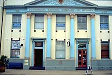
| Commercial Banking
Company of Sydney Building in the main street
|
Cessnock (including Bellbird, Nulkaba, Ellalong,
Paxton and Millfield)
Mining town in the Hunter Valley
151 km north of Sydney via the freeway Cessnock, together
with Bellbird, has a population of 17 914 and is situated
107 metres above sea-level. Although originally a service
centre to travellers and the surrounding farms its real
development as a town occurred when the area became a major
mining centre at the turn of the century. Consequently there
is little in the way of heritage buildings and today
Cessnock is essentially a rather unattractive and
uninteresting residential, commercial and government centre,
although it is situated adjacent one of the state's most
important wine-growing centres (see entry on
Pokolbin).
Depending on which source is consulted it is variously
believed that the original inhabitants of the area were the
Darkinjang, Awabakal or Wanaruah peoples.
Many early landholders in the Hunter Valley were of
Scottish descent. Some were the younger sons of noble
families who had come to take advantage of generous grants
when the family estate was bestowed upon the eldest son. One
such case was that of John Campbell who was granted 1560
acres in 1826 along Black Creek where the town is now
situated. He named the property after Cessnock castle in
Ayrshire, Scotland, which belonged to his baronial
grandfather. Unfortunately John died in 1828 at the age of
24 and his younger brother David returned to Scotland when
the grant was transferred to elder brother George, still
resident in his native land. George waived his rights in
1832 and David finally managed to secure a deed in 1834.
However, by that time, he too had decided to remain in
Scotland and he became an absentee landlord. Much of the
property was sold in an 1853 enabling the emergence of a
private village.
The locality was situated at an intersection on the Great
North Road. The first road to join Sydney with the Hunter
Valley it was built by 3000 convicts between 1826 and 1834.
The junction became a camping place for teamsters. The
Cessnock Inn was established here in 1856 for those
travelling between Wollombi and Maitland. By 1858 there were
still no more than eleven adults.
After the Robertson Land Act of 1861 the way was opened
for small landholders and people began to settle on small
farms along Black Creek and Anvil Creek in the area to the
north and north-west of Cessnock. They were mostly
wheat-growers but a German winemaker named Bouffier
established a vineyard at Cessnock around 1866. The township
developed as a service centre to local farmers and
travellers. Wheat-growing declined after rust destroyed the
crop in 1870.
With a view to establishing a village in the area, land
had been reserved for a church and school north of
present-day Cessnock as early as 1829. St Luke's Anglican
Church was finally built there in 1867, the original
slab-construction St Patrick's Catholic Church in 1872 and a
school in 1877. A village was laid out there in 1884-85.
Officially described as 'The Village of Pokolbin' it became
known as Cessnock later in the decade. That name was
transferred south to the town now called Cessnock in 1908
and the northern village became known by its local name,
Nulkaba, which was officially adopted in 1927. By that time
the farmland to the west had become known as Pokolbin.
Coal was discovered by William Keene in 1856 but the full
potential of the Greta coal seam was not recognised until
1886 when T.W. Edgeworth David did some exploratory work.
The first colliery (Richmond Vale) was opened in 1891 and
was linked by rail with Maitland. Closed in 1967 it is now a
mining museum. The East Greta, Stanford Merthyr, Pelaw Main,
Abermain, Aberdare and Hebburn collieries were all in
operation by 1906 (the names recalling the mining areas of
Wales and Northern England). Aberdare (opened in 1905) was
the first mine at what is now known as Cessnock.
The local mining operations were very large, even by
world standards. 17 collieries existed on the South Maitland
Coal Field, employing nearly 10 000 men and boys and thus
supporting a population of 43 000 in the district.
As a result of the collieries a land boom occurred
between the turn of the century and the early 1920s.
Subsequently the population, which had increased from 62 in
1871 to 165 in 1901, was 12 000 by 1926 when Cessnock became
a municipality. Coalmining was supplemented by wine-making,
timber, pottery, dairying and cattle.
Conditions at the mines were poor. The unionised
workforce pressed for central rescue stations in the mines
but their pleas were ignored. Some did not even have safety
lamps. Then, on September 1, 1923, 20 men and their horses
were killed in an underground explosion and fire at Bellbird
Colliery. One of the rescuers, John Brown, the manager at
Aberdare, also died.
Unrest continued throughout the 1920s. In 1929 Norman
Brown was shot and killed at Rothbury when police fired
their pistols to warn off thousands of miners protesting
against scab labour during a lock-out. A monument to what
has become known as the Rothbury Riots is located at North
Rothbury.
Many mines closed during the Great Depression of the
1930s. They reopened during World War II which were
profitable years for the mine-owners although unrest
continued over pay and conditions. Striking employees were
visited by novelist Katherine Susannah Prichard in 1944. The
methods employed by the owners to accelerate extraction
rendered vast amounts of coal inaccessible. The pits began
to close from the late 1950s and wine slowly supplanted coal
as the centrepiece of the local economy.
The City of Cessnock was declared in 1957 and the Greater
City of Cessnock in 1984. The latter incorporates 25
formerly separate towns and mining villages which mostly
developed around a particular colliery.
The Budburst Festival is held in September with a parade,
markets, events and the Miss Cessnock quest.
Things to see:
![[Top of page]](smlArrow.gif)
|
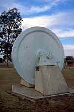
| Flywheel from Aberdare
Colliery near Tourist Information Office
|
Tourist Information
The Hunter Valley Wine Country Visitors' Centre is located
at Turner Park on Aberdare St, about 1 km east of the
intersection with Vincent St, Cessnock's main shopping
strip. Vincent St was originally known as Mt Vincent Rd as
it continued on to Ellalong and Mt Vincent. The information
centre has plenty of information on the area's wineries,
accommodation, restaurants and events.
Nulkaba
At the town's centre Maitland Rd, Wollombi Rd, Allandale Rd
and Vincent St all meet at what is left of Black Creek (now
cemented in and changed beyond recognition), along which the
Campbells received the first land grant in the area.
Head north along Allandale Rd which originally lead
through the farms which bordered Black Creek and Anvil
Creek. 1 km brings you to Nulkaba. With a view to the future
development of a village, land was reserved here for a
church and school during the first surveys of the area in
1829. St Luke's Anglican Church was built in 1867, the
original slab-construction St Patrick's Catholic Church in
1872 and a school in 1877. Intended as an administrative
centre for the district a village was laid out in 1884-85 as
'The Village of Pokolbin' but became known as Cessnock later
in the decade. That name was transferred to the town now
known as Cessnock in 1908 and the local name, Nulkaba, was
officially adopted in 1927.
|
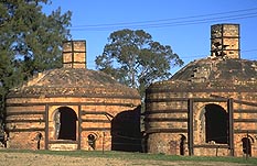
| Pottery kilns at Nulkaba
north of Cessnock |
As you drive north you can see, to the left, just past
the cemetery, St Patrick's Catholic Church (1892) then, to
the right, the interesting sight of some large and
unusual-looking pottery kilns (c. 1880). They are located in
the grounds of Potters Tavern.
Simply D'Vine Gallery and Gift Shop is situated at 49-53
Orient St, Nulkaba, tel: (02) 4990 4291.
Rusa Park Zoo
1.5 km north of the kilns is the turnoff into Lomas Lane, to
the right, which takes you a further kilometre to Rusa Park
Zoo, tel: (02) 4990 7714 or (02) 4990 1217. 1.4 km further
north along Branxton Rd is Tandem Skydiving, located at
Cessnock Airfield, tel: (02) 4990 1000.
St John's and Marthaville
Head south-west from Cessnock's main intersection along
Wollombi Rd. The Wollombi-Maitland Rd was originally part of
the Great North Rd, built by 3000 convicts between 1826 and
1834. The first right is Westmacott St where you will find
St John's Anglican Church (1909) designed by Cyril Blacket.
Return to Wollombi Rd and continue south. Just past the
first roundabout, to the right, is a signpost indicating
'Historic Marthaville' (1889), now an arts and cultural
centre, open Friday to Sunday.
Bellbird
Continue south-west along Wollombi Rd for 4 km to Bellbird
where two collieries once operated. At the corner of
Wollombi Rd and Kendall St is the Bellbird Mining Disaster
Memorial in a small and unremarkable park to the right.
This simple monument stands opposite the site of Bellbird
Colliery where, on Saturday, September the 1st, 1923,
explosions and fires underground killed 20 men and their
horses. Another man, John Brown, the manager at Aberdare,
died in the rescue attempt. Working conditions at the time
were very poor. The unionised workforce had pressed for
central rescue stations in the mines but their pleas were
ignored. Some did not even have safety lamps.
25 000 people attended the ensuing mass funeral.
Subsequently the Central Mines Rescue Station was formed.
Unrest continued throughout the 1920s. In 1929 Norman
Brown was shot and killed at Rothbury when police fired
their pistols to warn off thousands of miners protesting
against scab labour during a lock-out. A monument to what
has become known as the Rothbury Riots is located at North
Rothbury on the western side of Branxton Rd.
Lookouts
A signpost at the corner of Kendall St and Wollombi Rd
indicates that it is the route to Bimbadeen scenic lookout.
Follow this road, with the mountains dead ahead, for 4 km.
It is then necessary to take a very sharp left turn. After
about another 600 m turn left again through a little gateway
with 'Bimbadeen' overhead.
Here you can join the Great North Walk. Sydney Cove is a
mere 190 km distant, Newcastle 92 km, the Paxton Hotel 8 km
and Pokolbin Rest Area 9 km. The views are excellent. To the
east are a series of mountains. The tallest, capped by two
large television transmitters, is Mt Sugarloaf where there
is another outstanding lookout (see entry on
Newcastle). In between is a very flat valley with
occasional pockets of human habitation. Cessnock is in the
near distance with Kurri Kurri further east and Maitland
just discernible. The Watagan Mountains are to the right
(south).
If you do not take the side road to Bimbadeen but
continue along the main road, which becomes gravel after a
short distance, you soon come to a fork. The right path
leads up to Mount Bright Lookout. There is little to
indicate its existence. You simply park your car on the side
of the road and walk a short distance to a good vantage
point although these can be hard to locate amidst the dense
tree growth.
Millfield
Return to Wollombi Rd. 7 km south of Kendall St you will
come to the pleasant and peaceful locality of Millfield. The
land here was taken up by ex-convicts Patrick and Eupheme
Dowlan in 1828. When the Great North Road went through the
following year they set up an inn adjacent the thoroughfare.
A village subsequently developed serving farmers and
travellers.
Note the road on the left which leads through Paxton to
Ellalong. 700 m beyond this turnoff you will come to the
crest of a small hill where there are two buildings of
interest.
The old slab hut to the left was licensed in 1838 as The
Rising Sun Inn. The licensee was Thomas Pendergast. In 1840
it was held up by bushranger Edward Davis and his gang while
Pendergast was being visited by John McDougall of Wollombi.
After being robbed McDougall received a dozen lashes because
of his reputation for being 'over fond of flogging whilst
overseer of an iron gang' during the construction of the
Great North Road. When McDougall's inn at Wollombi closed in
1845 he purchased the Rising Sun which is now a craft
gallery and museum of sorts.
St Luke's opposite has an old bell from one of the oldest
and largest properties in the district, Brown Muir. The
owners, Robert (former chief clerk to the Colonial
Secretary) and Thomas Crawford, were amongst the largest
landholders in the area (8000 acres).
Further south is the beautiful old village of
Wollombi.
Ellalong and Paxton
Return to Cessnock through Paxton, which grew around
Stanford Main No. 2 Colliery, and Ellalong. After 9 km you
will pass the Paxton Hotel and come to the crest of a small
hill where there is an intersection. A right will take you
south into the Congewai Valley, all of which was once owned
by Thomas Crawford. A left turn leads, after 4 km, back to
the Wollombi Rd just south of Bellbird.
This intersection is a good spot to view the rather
attractive Ellalong Swamp. Never known to have run dry these
wetlands are part of Quarrybylong Creek which flows into
Congewai Creek. The mountains in the distance are the
Watagans.
If you proceed straight ahead then, after 2 km, there is
another turnoff on the left which also leads back to the
Wollombi Rd, this time through the old mining village of
Ellalong, originally a grant made out to Robert Crawford.
If you do not take this left the road continues on to
Heaton Lookout which is 24 km distant (see entry on
Cooranbong).

Broadwalk
Business Brokers
Broadwalk Business
Brokers specialise in General Businesses for Sale, Caravan Parks for
Sale, Motels for Sale, Management Rights & Resorts for Sale, Farms for
Sale, Hotels for sale,Commercial & Industrial Properties for Sale.
Phone:
1300 136 559
Email:
enquiries@broadwalkbusinessbrokers.com.au
AUSTRALIAN BUSINESSES FOR SALE
COFFS HARBOUR BUSINESS BROKERS
BROADWALK BUSINESS BROKERS
GOLD COAST BUSINESSES FOR SALE
BRISBANE BUSINESSES FOR SALE
SYDNEY BUSINESSES FOR SALE
CARAVAN PARKS FOR SALE
BUSINESSES FOR SALE
MOTELS
FOR SALE
HOTELS
FOR SALE
Disclaimer
We advise prospective purchasers that we take no
responsibility for the accuracy of any information in the business
provided by vendors or their professional advisers and that they should
make their own enquiries as to the accuracy of this information,
including obtaining independent legal and/or accounting advice
Cessnock