|
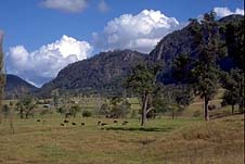
| The Bucketts behind
Gloucester |
Gloucester
Quiet rural township on the edge of the Bucketts.
Gloucester, known as the gateway to the Barrington Tops, is
a charming country town nestled in a valley under a range of
impressive monolith hills called The Bucketts. It is
situated on the Gloucester River 96 metres above sea-level
and is located 271 km north-east of Sydney on the Bucketts
Way which heads northwards off the Pacific Highway 18 km
from Raymond Terrace, passing through
Stroud and, at Gloucester, veering east to rejoin the
highway at
Nabiac. To the east of town is the Mograni Range and
just to the north of town, the Gloucester, Avon and
Barrington Rivers meet. Gloucester has a population of
around 2600. It is the principal town of a cattle-raising,
dairying and mixed farming district. Local industry includes
a large factory which produces milk products, a coal mine,
an important cattle market and a nascent tourist industry
based on the area's fine natural attractions.
Prior to European settlement, the area was inhabited by
the Kattang Aborigines. The first European known to have
passed through the area was the explorer Henry Dangar in
1826. Hot on his heels was Robert Dawson, the first manager
of the Australian Agricultural Company (AAC) which had been
formed in England in 1824 with the object of raising fine
wool and agricultural products for importation to England.
The AAC had been granted one million acres on the northern
side of Port Stephens and, impressed by the 'romantic
scenery' of the river valley, Dawson established an
outstation which he named 'Gloucester' after the English
town as the landscape reminded him of the terrain in
Gloucestershire. The Gloucester and Avon valleys were soon
full of AAC sheep and a dairy was established on the estate
c.1831 for the supply of AAC employees.
In 1851 churchman John Dunmore Lang observed that
'Gloucester is one of the best sites for an inland town, I
have ever seen in the colony. A range of picturesque
mountains, called by the aborigines, the Buccans, of about
1200 feet in height, bounds the horizon to the westward.
Along the base of these mountains, the River Gloucester
wends its way to the northward, leaving a large extent of
alluvial land on its right bank, which the Company has
cleared and brought into cultivation; the site of the
buildings that form the station, including a house of
accommodation for travellers, being on a rising ground to
the eastward of the alluvial flats. It is altogether a
beautiful spot in the wilderness'.
Drought killed off many sheep in the early 1840s. The end
of transportation in the 1840s and the goldrushes of the
1850s caused labour shortages for the company which imported
Chinese hands. In addition, the sheep flocks suffered as
Dawson had chosen inappropriate terrain, attempts to grow
grain proved disappointing, the paddock fences were in a
parlous state and half the cattle and horses were astray,
lost or stolen. By the 1870s the Gloucester estate was
overrun with brumbies and 1500 were shot.
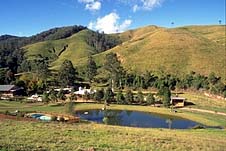
|
| Hookes Creek near
Gloucester |
In the late 1850s the AAC sold or removed all the sheep
and reduced its landholdings in the area. Attention turned
primarily to cattle with the Gloucester estate proving home
to a large and excellent herd. Coal, iron ore and limestone
deposits were discovered by the AAC but plans for their
exploitation never came to fruition.
In 1856 Arthur Hodgson, the general superintendent of the
AAC, observed that 'the town of Gloucester is laid out with
great judgment. The road from New England passes through a
part of it. There is a house of accommodation about one mile
from the township'. Although Gloucester was the head
station, the term 'town' is probably misleading as there
were few buildings. In 1861 the only structures were a
slab-and-bark hut occupied by the resident constable, a
wooden hotel with a shingle roof, an Anglican church (built
in 1860 at the expense of the AAC) and a blacksmith's shed.
Elsewhere on the estate there were cattle yards, which held
up to 4000 head, an overseer's house, and a brick residence
for the usage of the general manager who moved to Gloucester
from Stroud in 1860. A store and two houses were added to
Gloucester in the 1860s with another two residences, a post
office, an hotel and a police station being added in the
1870s.
In the 1850s and 1860s there were still many Aborigines
in the area. They camped and held corroborees on the future
townsite and helped the early settlers at harvest time. Once
each year they gathered at Gloucester before proceeding to
Stroud where they were issued with a blanket apiece.
Notorious bushranger, 'Captain Thunderbolt' (Fred Ward)
hid out at Gloucester Tops in the mid-1860s. When the police
discovered his hideout in 1866 he escaped, though his wife,
his two children and another woman were taken to Gloucester
and on to Maitland where the women were released. The two
children were sent to a government institution.
Alluvial gold was discovered to the west of Gloucester,
at present-day Copeland, in 1872, but it was kept secret
until 1876 when a rush started. Subterranean mining
commenced in 1877 and, at the height of the rush (1877-80),
there were some 3000 people in the area working 51 reefs
which yielded 566 kg of gold. Half of that amount was
uncovered in 1879 alone.
In 1903 the AAC sold its property to the Gloucester
Estate Syndicate which cleared the land, drew up the town
subdivision and sold allotments. In 1905 two hotels were
built, a school of arts was completed, the 'Gloucester
Advocate' went into print and construction began of other
businesses and residences. At that time cattle and timber
were the focus of local industry although dairying was on
the rise. In 1906 the Barrington Butter factory opened and
the Gloucester Shire Council held its first meeting. A
Presbyterian Church was built in 1907 and the courthouse was
erected in 1908. A cordial factory operated from 1910-1918
and the railway arrived in 1913, enhancing the town's role
as a service centre to the surrounding area and
precipitating a period of development.
The Gloucester National Dancing Competition is held every
July and the Agricultural Show in March or April.
Things to see:
Tourist Information
Gloucester Tourist Information Centre is located at the
corner of Church and Denison Streets. It is open daily from
9.00 a.m. to 4.30 p.m. (8.30 a.m. to 5.30 p.m. in school
holidays) and offers an accommodation booking service, maps,
historical and local interest literature, local arts and
crafts and postcards. Contact them for information about
scenic drives, picnic areas, bushwalking and fishing. The
waters of the Barrington, Manning and Barnard Rivers are
noted for quality canoeing and the information centre can
furnish details on local canoe hire and potential routes,
tel: (02) 6558 1408.
The Homestead
The homestead is located opposite the saleyards, on the
western side of The Bucketts Way at the southern end of
town. It is a single-storey sandstock brick residence built
c.1830 by the Australian Agricultural Company on what was
then the main north coast road. It is currently a private
residence.
School Museum
Just to the north, at the corner of the Bucketts Way and Oak
St, is St Clement's Historic Park. Gloucester's first church
was built here by the Australian Agricultural Company in
1860. Just behind the park is the Upper Bowman School Museum
which is a typical 19th-century, one-teacher, rural
schoolhouse with original furniture. It is open by
appointment, tel: (02) 6558 1882.
Folk Museum
From here the Bucketts Way is known as Church St. At 12
Church St is the Gloucester Folk Museum which is located in
the former shire council chambers (1909). The Wunderlich
pressed-metal ceilings are of interest and, to the rear of
the building, are the police lock-up and an explosives store
from the former goldmining town of Copeland. It is open
Thursdays and Saturdays from 10.00 a.m. to 12.00 noon and on
Tuesdays in the school holidays, or by appointment, tel:
(02) 6558 1882.
Bucketts Scenic Walk and Bucketts Circle
Head out of town along Park St which soon becomes the
Barrington Tops Forest Rd. After 1 km turn left into
Bucketts Road. 1 km along this road, to the right, is the
signposted start of the Bucketts Scenic Walk (2 km but
steep) which leads up the Bucketts Mountain Range where
there are excellent views of the Gloucester and Avon
Valleys.
Those wishing to extend the trip into a scenic drive can
continue along Bucketts Road for another 8 km then turn
right onto Faulkland Rd. After fording the river three times
in 3 km, turn right over the river then right again on to
Barrington East Road. At its end turn right to return to
Gloucester. Half of this 30-km drive is sealed.
Kia-Ora Lookout and Tourist Drive 4
About 4 km from the centre of Gloucester, via Barrington
Tops Forest Rd, is the Bowman Farm turnoff (signposted) on
the right. Follow Tourist Drive 3 for another 3 km to
Kia-Ora Lookout (watch out for the sharp left turn off the
bitumen) which offers truly panoramic views of the district.
If, instead, you follow Tourist Drive 4 to the
north-west, it leads along an unsealed road through river
flats and ridge country. At its end turn left onto
Thunderbolts Way (sealed) then left again, after 7 km, back
onto Barrington Tops Forest Road.
Mountain Maid Goldmine
Continue west along Barrington Tops Forest Rd through the
villages of Barrington (established in 1897) and the former
goldrush town of Copeland where gold was discovered in 1872.
17 km from Gloucester there is a clearly signposted
turnoff on the left along Old Copeland Rd. It is about 200 m
to the Mountain Maid Goldmine carpark. The Mountain Maid
Goldmine commenced operations in 1876 and did not close
until 1979. There are underground tours, restored equipment,
a cedar slab hut, goldpanning, an inspection of the
workings, rainforest walks and picnic-barbecue facilities.
It is open Wednesday to Sunday from 9.30 a.m. to 3.30 p.m.
and every day in school holidays. For further information
ring (02) 6558 4303 or go to
www.excursions.tac.com.au/goldtownsnsw
Dilgry Circuit
Just to the west of the Old Copeland Road turnoff, the
bitumen of Barrington Tops Forest Rd peters out leaving a
winding gravel road negotiable in a 2WD (be careful in wet
weather).
54 km from Gloucester you can turn right at the Dilgry
sign. This unsealed loop road traverses 18 km of scenic
countryside before returning to Barrington Tops Forest Road.
Devils Hole
About 60 km from Gloucester, via Barrington Tops Forest Rd,
is the Devils Hole Lookout Day Use Area which offers fine
views over the Barrington Wilderness and adjoining
farmlands. It is, in fact, one of several lookouts which are
signposted along the Barrington Tops Forest Road.
Polblue and Walking Trails
About 70 km from Gloucester, along Barrington Tops Forest
Rd, is the Polblue Camping Area, situated within Stewarts
Brook State Forest, from whence the Barrington Tops Plateau
Walk commences. It is about five hours (one way) through
sub-alpine woodlands and wetlands, past the Little Murray
and Big Hole camping areas, to Careys Peak (1545 m) which
offers spectacular views over the Barrington wilderness and
the Hunter Valley. Once at Careys Peak there are extensions
south to Lagoon Pinch and east to Gloucester Tops. For
further information on Barrington Tops National Park ring
the National Parks and Wildlife Service on (02) 6558 1478.
4WD Trail and Other Roads
From a point near Polblue, the Barrington Trail (4WD only)
heads south off Barrington Tops Forest Road, past the Little
Murray and Junction Pools camping areas to Mt Barrington
(1558 m) from whence it is a 7-km walk to Careys Peak. The
Middle Ridge Trail joins the Barrington Trail just before Mt
Barrington, heading north-west back to the Barrington Tops
Forest Rd. It traverses private property and both 4WD trails
are closed from 1 June to 30 September each year.
93 km from Gloucester, along the Barrington Tops Forest
Rd, is the turnoff on the right to Moonan Flat (see entry on
Gundy) and beyond lies
Scone. A number of side roads (some 4WD only) lead off
Barrington Tops Forest Rd to camping areas within Stewarts
Brook State Forest.
Woko National Park
9 km west of Gloucester along Barrington Tops Forest Rd (1
km west of the village of Barrington) is the turnoff on the
right onto Thunderbolts Way (the road north to
Walcha). 11 km along this road (just beyond the locality
of Rookhurst) turn left onto Curricabark Road which soon
becomes gravel. Just before the first causeway over the
Manning River turn right onto the flood detour road which
leads to a secluded campground by the river within Woko
National Park (8265 acres) which is located on rugged land
once occupied by the Birripi people. The campground is
located on a former cattle property. There are fireplaces,
pit toilets and picnic facilities, but collecting wood is
forbidden so bring your own, or a fuel stove.
The Scrub Turkey Circuit (20 minutes return) leads
through dry rainforest (where bush turkeys are often seen)
then dry sclerophyll forest before rejoining the gravel
road. Turn left at the road to return to the campground.
The Cliff Face Walk is steep and takes about two hours
(return).It branches off to the right from the Scrub Turkey
Track, passing through pockets of sub-tropical rainforest
and past rocky outcrops from the escarpment above.
Swimming and liloing can be enjoyed on the river and
hiking off the beaten track is possible for experienced
bushwalkers.
Bretti Reserve and Thunderbolts Way
34 km north of Gloucester, along Thunderbolts Way, is a
turnoff on the right to the locality of Bretti. There is a
camping and picnic area on the banks of the Barnard River
where swimming and canoeing can be enjoyed. There are picnic
and barbecue facilities.
If you follow Thunderbolts Way north to
Walcha it passes through Giro State Forest and some fine
mountain and river scenery.
Gloucester Tops
9 km south of the town centre, via the Bucketts Way, is
Gloucester Tops Rd which heads off to the west. Follow this
road for 7 km, turn left at Faulkland then left again at
Invergordon (22 km from the Bucketts Way). About 30 from the
Bucketts Way is the Gloucester River Camping Area. Wildlife
in the area includes lyrebirds, red-necked pademelons and
brush turkeys.
Gloucester Tops Rd continues on its winding way for about
another 18 km to Gloucester Tops Day Use Area, from whence
there are a number of walks (some short, some lengthy),
including the Link Trail to the Barrington Tops plateau. A
shorter walk leads to Gloucester Falls. There is a diversity
of vegetation in the area, including Antarctic beech forest,
snow gum forest and swamps.
Mograni Lookout
Mograni Lookout is located 5 km east of Gloucester along the
Bucketts Way. It furnishes excellent views of Gloucester
Vale. There is also a picnic-barbecue area but no water.
Bundook
A left turn off the Bucketts Way at Mograni Lookout will
take you through the fine scenery of the Gloucester Valley
to Bundook. From there veer south back to the Bucketts Way
then turn right and head back to the lookout. This route
covers 56 km, half on unsealed roads.

Broadwalk
Business Brokers
Broadwalk Business
Brokers specialise in General Businesses for Sale, Caravan Parks for
Sale, Motels for Sale, Management Rights & Resorts for Sale, Farms for
Sale, Hotels for sale,Commercial & Industrial Properties for Sale.
Phone:
1300 136 559
Email:
enquiries@broadwalkbusinessbrokers.com.au
AUSTRALIAN BUSINESSES FOR SALE
COFFS HARBOUR BUSINESS BROKERS
BROADWALK BUSINESS BROKERS
GOLD COAST BUSINESSES FOR SALE
BRISBANE BUSINESSES FOR SALE
SYDNEY BUSINESSES FOR SALE
CARAVAN PARKS FOR SALE
BUSINESSES FOR SALE
MOTELS
FOR SALE
HOTELS
FOR SALE
Disclaimer
We advise prospective purchasers that we take no
responsibility for the accuracy of any information in the business
provided by vendors or their professional advisers and that they should
make their own enquiries as to the accuracy of this information,
including obtaining independent legal and/or accounting advice
Gloucester