|
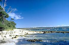
| The beautiful white sands
of Jervis Bay |
Jervis Bay (plus Currarong, Callala Beach, Callala
Bay, Myola, Vincentia and Hyams Beach)
An area of brilliant white sands and pleasant
bushwalking.
Located about 170 km from Sydney, Jervis Bay is both an
inlet and the basis of the uniquely beautiful Booderee
National Park which is a popular holiday destination.
The Bay itself is approximately15km long and 10km wide.
It is a spacious natural harbour sheltered by headlands of
forest and heathland which jut out leaving a relatively
narrow entrance. With a depth of 27 metres it is thought to
be the deepest sheltered harbour in Australia. The waters
are remarkably beautiful and range in hue from aquamarine to
a deep blue.
The fauna and the flora are diverse. There is eucalypt
forest, woodland, swamps, dunes, mangrove, rainforest
relics, coastal scrub, grassland and a heathland rich in
wildflowers.
There are lakes and estuaries, historic sites, high sandy
ridges, a coastline of coves, majestic cliffs up to 135
metres, and beaches noted for their length and the
remarkable whiteness of their sands.
There are many middens and rock shelters which indicate
that Aborigines have been living in the area for at least 20
000 years. Given that the Bay is thought to have been formed
only 11 000 years ago, after the last ice age, it is likely
that the Aborigines have been there from the beginning.
It is a comment on the continuity of Aboriginal
settlement that one community still lives in a protected
area near Wreck Bay on the southern peninsula and the
Jerringa people still live in an unprotected area on the
northern peninsula.
The archaeological evidence indicates that the original
inhabitants moved regularly from place to place within the
area. They tended to camp in the open on headlands or along
the beaches, though sometimes in more secluded rock
shelters.
A few eucalypt trees in the area still bear ancient scars
from those occasions when bark was stripped for shelters and
canoes. Their diet consisted of shellfish, fish from the
estuaries and small marsupials, penguins and mutton birds
from excursions to Bowen Island. Tools for cutting,
chopping, scraping, sewing and killing were made of Captain
Cook sighted the Bay in April 1770 while sailing north along
the coast. In his diary he wrote of a 'point of land which I
had discovered on St George's Day, and which therefore I
called Cape George' [Cape St George].
While in the vicinity Cook noted 'smoke in several places
near the beach'. Arriving at the Bay he recorded that it
'promised shelter from the north east winds, but as the wind
was with us, it was not in my power to look into it without
beating up, which would have cost me more time than I was
willing to spare'. He named the northern point of the bay
'Long Nose', the whole resembling a face in profile.
The bay became 'Jervis Bay' in August 1791 when
Lieutenant Richard Bowen, named it Port Jervis after naval
officer and, later, admiral of the British fleet, Sir John
Jervis under whom Bowen had served.
Whalers from Twofold Bay began to frequent Jervis Bay in
the 1790s using it for anchorage. In 1801 naturalist and
explorer George Caley arrived aboard Lieutenant James
Grant's Lady Nelson and between them they made favorable
reports of the flora, fauna and safety of the harbour.
Governor Macquarie landed on Bowen Island in 1811 and
subsequently recommended a settlement at the Bay. In 1818,
he sent explorers Charles Throsby and Hamilton Hume to seek
a route from the southern tablelands to Jervis Bay. Throsby
completed the journey. In 1819 the surveyor-general John
Oxley sailed to the Bay. He reported that there was not 'the
smallest inducement for the foundation of a Settlement on
its shores, being ... for the most part Barren and generally
deficient in Water'.
The first land grants were issued in 1827. It was the
cedar in the area that provided the initial industry though
dairying soon developed. When wool prices soared at the
outset of the 1840s Governor Gipps sent 70 convicts to cut a
track that has become known as The Wool Road from Braidwood
to the Bay so that wool could be shipped to Sydney. As a
result there was great optimism about the future of the
district, and the settlement of Huskisson was established on
the western shore of the Bay in 1840. A hotel, wharf and
wool store were soon erected at South Huskisson and wool
shipments were made to Sydney and London. Coastal steamers
and whaling ships were regular visitors.
The combination of projecting headlands, steep cliffs,
rocky shoreline, currents and strong easterly winds proved a
hazard to sailing vessels. Cape St George Lighthouse was
constructed in 1860. However it was erected at the wrong
spot, several kilometres north of Cape St George. As a
result it was imperceptible to ships coming from the south
and, ironically, proved a navigational hazard by day.
Consequently, Point Perpendicular Lighthouse was built at
the southern tip of the northern peninsula in 1899 and the
earlier structure was used as target practice by the Navy.
The ruins of the base, part of the tower and the
outbuildings remain.
There have been a number of shipwrecks around Jervis Bay
over the years. The first to be recorded was the 20-ton
sloop Nancy in 1805, at the cost of one life. In 1876 40 men
died when the steamer Dandenong went down. In 1927 the wreck
of the SS Merimbula marked the end of passenger services by
sea along the south coast. Most dramatically of all, in
1964, the HMAS Melbourne collided with the HMAS Voyager in
1964 during a naval exercise and 82 men were killed.
After Federation occurred in 1901 plans were set in
motion to create a city (ultimately Canberra) within an
independent territory (the ACT) wherein the new Federal
Government could sit. The subsequent Seat of Government Act
(1908) declared that access to the sea was imperative. Thus
7400 hectares of land at the southern end of Jervis Bay were
officially handed over from the NSW to the Commonwealth
Government to be developed as a port and naval base. Work
began in 1913 and, in 1915, the Royal Australian Naval
College opened at Captain Point under Federal administration
as HMAS Creswell. The Royal Australian Naval College no
longer exists as it was absorbed into the Australian Defence
Force Academy but some officer training still occurs at
Jervis Bay. A majority of the original buildings remain.
Adventurer Sir Francis Chichester, who later became the
first person to sail around the world single-handed, landed
his aeroplane in Jervis Bay in 1931 at the end of what was
the first east-west flight over the Tasman Sea from New
Zealand to Australia.
The Wreck Bay area was designated a reserve in 1928 but,
by the time it was gazetted in 1952, the extent of the
reserve had shrunk considerably. In 1971 two-thirds of the
Territory (4470 hectares) was declared a natural reserve.
Five years later the whole was classified by the National
Trust of Australia in recognition of its conservation,
scenic, scientific, historical and recreational value. Cape
St George Lighthouse, Bowen Island and HMAS Creswell have
been included on the Register of the National Estate.
Today the National Park attracts nearly a million
visitors a year. In December 1995 it was handed over to the
Wreck Bay Aboriginal community as part of the reconciliation
process. The agreement saw the land leased back to the
Federal Government for 99 years in return for a share of the
income the park generates and a majority presence on the
management board. The current occupants are all descended
from or related to the original inhabitants. Many of the
sites are of great significance to them, especially the
Reserve Cemetery, fishing spots at Summercloud Bay and Mary
Bay, as well as traditional lookouts, meeting places and
camping areas. As part of the process the name of the
reserve has been changed from Jervis Bay National Park to
Booderee National Park
If you want to fully explore the entire coastline around
the Bay it is important to realise that the land which
surrounds it is actually cut by Currambene Creek which
reaches the shores of Jervis Bay just north of Huskisson.
Access to the southern section is via Jervis Bay Road, 10
km south of Nowra. To go from Huskisson to Myola - the next
beach north - you have to either swim across the creek or
drive back to the Highway and head north, taking Currarong
Road through Currambene State Forest, or return to Nowra and
take the sealed road east and then turn south.
Things to see:
![[Top of page]](smlArrow.gif)
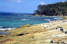
|
| Rocky outcrop at the end
of Nelsons Beach, Vincentia |
Vincentia
4 km south of Huskisson and just east off Jervis Bay Road is
the small resort town of Vincentia. It was originally South
Huskisson but was renamed in 1952 after John Jervis, after
whom Jervis Bay was named, who was also the Earl of St
Vincent. Vincentia is a typical holiday town. There are the
usual modern facilities, long beaches and the waters are
good for fishing, windsurfing, sailing and diving.
The first left off Elizabeth Drive is Holden St which
will take you out to the Bay and a concrete boat ramp. If
you continue along Elizabeth Drive, Plantation Point Parade
branches off to the left and leads to a natural ramp for
catamarans and skiffs. At the western end of the small
township, in Murray St, is a nine-hole golf course with
excellent views over the Bay and south to Pigeon House
Mountain.
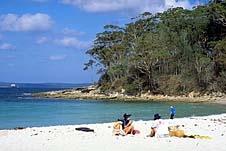
|
| Blenheim Beach
|
Hyams Beach
Hyams Beach is a quiet village which claims to have the
whitest sand in the world. The town was named after Michael
Hyam who received a grant of 41 acres of waterfront land
there in 1859. There is a concrete boat ramp off Cyrus St
into the Bay. Hyams Beach is also a recommended diving spot,
at least at high tide. From the boat ramp swim out due east
for 100 metres. There are a number of shallow reefs in 8-10
metres of water and a variety of temperate marine life. The
site is not suitable during easterly swells or
north-easterly winds.
Booderee National Park
Booderee National Park Visitors Centre is open from 9.00
a.m. to 4.00 p.m. every day in the off-season and from 8.30
a.m. to 5.00 p.m. from the commencement of the Christmas
school holidays to the end of the Easter weekend. Bookings
for camping can be made here and should be done so four
months in advance, tel: (02) 4443 0977. The centre has
pamphlets about the Park, its walking tracks and other
information.The nature trails are signposted and, in the
peak season, walks are conducted by rangers and illustrated
with a slide show at Green Patch. They will also take
prospective divers to the appropriate locations about the
Bay.
No spears, spear guns, dogs or other domestic animals are
permitted, fires can only be lit in specified barbecue areas
and driving of all vehicles is only permitted on designated
roads. The cost of entry is $5 per car per week.
The reserve boasts a diversity of fauna. There are great
gliders high in the tree canopy, tiny feathertail gliders
(featured on the old one-cent coin), sugar gliders with
their distinctive yapping call, ringtail, brushtail and
pygmy possums, eastern grey kangaroos, red-necked and swamp
wallabies, echidnae, dunnarts, bandicoots, bush and swamp
rats, bats (responsible for the clicks and squeaks often
observed by visitors) tortoises, lizards, red-bellied black
snakes, death adders, diamond pythons, and plenty of frogs.
Amongst the 170 species of birds are crimson rosellas,
king parrots, kookaburras, satin bowerbirds, pied
currawongs, magpies, wattlebirds, cockatoos, honeyeaters,
spinebills, gulls, terns, the high-diving Australian gannet,
curlews, dotterels, greenshanks, shearwaters, and the little
penguins that burrow and breed on Bowen Island.
The reserve is also a haven for several endangered
species - the white-bellied sea eagle, the ground parrot and
the eastern bristlebird.
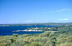
|
| HMAS Creswell
|
HMAS Creswell
Soon after leaving the information centre you will see, to
your left, the naval college, HMAS Creswell. Access is
restricted. Visits of 20 minutes are permitted on weekends
and most public holidays. It is advisable to ring the gate
to confirm the opening hours on the day of a prospective
visit as there can be variations (02 4429 7985).
On the grounds is the Royal Australian Naval College
Historical Collection, containing artefacts relating to the
college and the Jervis Bay area and an extensive collection
of model sailing ships. It can be seen on the last Sunday of
each month; otherwise it is by appointment only (phone 02
4429 7845).
The main buildings around the quadrangle - the Clock
Tower, the Dining Hall, the College Hospital (now the
sailor's mess) and the marvellous two-storey timber
Commandant's House - have all been listed for preservation
by the National Trust. The predominant architectural values
expressed in the highly geometrical layout and design of the
college are, not surprisingly, formality, symmetry and
simplicity. All of the original buildings are of
weatherboard cladding with red tiled roofs. Incorporating
touches of Georgian and classical design they are impressive
examples of Australian colonial architecture.
Iluka
Iluka is located in a bush setting. It has picnic, barbeque
and toilet facilities, with drinking water and access to a
safe swimming and fishing beach.
Green Patch
Green Patch has a popular and beautiful camping ground that
accomodates caravans as well as tents. There are picnic
tables, good barbecue facilities, toilets, hot showers but
no power, an excellent sheltered beach and, best of all,
hundreds of tame rosellas. The birdlife here is prolific,
the flora is diverse, there are dolphins and penguins to be
seen in the Bay and kangaroos about the campsite. The
maximum permissable stay is three weeks.
Bristol Point
Bristol Point campground is a little further along Jervis
Bay Road. It has large campsites, hot water and barbecues
but no power nor caravan sites. There are several walking
trails around the Green Patch and Bristol campgrounds, such
as that which follows fern-lined Telegraph Creek south
through woodland and low heathland rich in wildflowers and
birdlife. The Rock Platform nature trail takes you out to
Bristol Point for a wander along the rocky shore.
Murrays Beach
Beyond Green Patch, along Jervis Bay Road, several short
walking trails lead to Scottish Rocks and the Hole in the
Wall. At its end is Murrays Beach, recognised as a highlight
of the reserve. From the large carpark you walk to the
shore, only to find a boat ramp and a small beach with rocky
outcrops. If you are disappointed don't worry. This is not
Murrays Beach. That lies a short 1.4 kilometre walk away
around a rocky point and it is as beautiful as everyone
suggests. A walking trail will take you on to Governor Head
with its sandstone cliffs towering 90-120 metres above the
waves. The trail continues south, as coastal scrub gives way
to heathland, down to the end of Stony Creek Road then back
north again to Murrays Beach. The cliffs here, with their
coloured sandstone layers, extend all the way down the
eastern coast of the peninsula and around to St George Head
on the southern side of the promontory.
Both Green Patch and Murrays Beach boat ramp are
recommended locations for diving. Snorkelling spots are
abundant. There are shallow and deep-water rock reefs, sand
zones, seagrass meadows, silty sand-flats, platforms and
caves to explore.
Bowen Island
Bowen Island, opposite Governors Head, is 51 hectares of
heath, woodland and tussock shrubland. The gnarled nature of
the Island's banksia are of particular interest. The area is
populated with shearwaters, little penguins and their
burrows. There are sites of archaeological importance
including shell and bone middens and rock shelters. On the
north of the island are World War II gun emplacement sites
facing out to sea, mountings for heavy guns, lookout posts
and underground complexes for barracks and magazine stores.
Australian National Botanic Gardens Annexe
If you turn to the right into Cave Beach Road just over a
kilometre past the visitor's centre, it will take you past
Lake Windermere to the Australian National Botanic Gardens
Annexe, an area of approximately 80 hectares characterized
by sandstone outcrops, swamplands and wet gullies.
The Annexe was established in 1951 to 'cultivate a local,
regional and national collection of frost tender species
which will not grow in the main Gardens in Canberra.' The
result is an extensive collection of native plants spread
over 80 hectares. The site is open from 8-4 on weekdays,
10-5 on Sundays, public holidays and every Saturday between
Christmas and Easter. There are nature walks, toilets and
picnic areas.
Cave Beach and Bherwerre Beach
Continue down to the end of Cave Beach Road (it is unsealed
beyond the gardens) to the carpark. A trail will take you
the 300 m through coastal scrub to the beautifully-situated
Cave Beach campsite where swamphens can often be seen
scavenging for food. It offers toilets, picnic facilities,
barbecues and cold showers. From here you can either
continue south to the beach, ideal for fishing and swimming,
or head west through some rainforest to Bherwerre Beach
where there are views to the south, and west to the
mangroves and swamps on the shoreline of St Georges Basin.
The dune vegetation at Bherwerre Beach is threatened by an
introduced species, the Bitou-bush, which was intended as a
stabiliser after grazing damage threatened the spread of the
dunes inland. Both Cave and Bherwerre are recommended
surfing locations.
If you want a longer walk there is a fire trail which
heads south-west from the road through tall blackbutt
forest, coastal tea-tree and revegetated dunes down to
Bherwerre Beach (1.9 km). There is a 200-m detour that heads
east from the fire trail to Ryans Swamp, full of egrets,
ibises, swamphens and herons when flooded.
Wreck Bay
To the east is Wreck Bay where there are a series of sandy
bays with sheltered beaches. The area is accessible via
Wreck Bay Road which heads south from Jervis Bay Road 2 km
east of the Cave Beach Road turnoff. There is a path which
turns off to the left before the 87-hectare Aboriginal
settlement and then heads south again towards secluded
Summercloud Bay, a pretty little cove with a ramp, toilets,
picnic tables, barbecues, drinking water and beautiful
beaches set against a backdrop of Blackbutt forest.
The rock platform is popular with snorkellers. Both
Summercloud and Shelleys Point to the east are popular
surfing spots.
The cliffline around to Governer Head commences here. The
peninsula features a number of secluded sandy coves nestled
in rock platforms, surrounded by dense eucalypt forest. The
track south to St George Head passes through forest,
woodland, coastal scrub and patches of rainforest with
detours heading out to Shelleys Point, Whiting Beach, Blacks
Harbour, Kittys Beach, Kittys Point and Corangamite on the
coast.
If you follow the trail to its southernmost point there
are spectacular ocean cliff views at the Head (4.1 km or 1.5
hours walk from the carpark). From there you can return
north the way you came or head north-east to Brooks Lookout
where there are great views of Steamers Head. Its 135-metre
cliffs are thought to be the tallest on the NSW coast.
Alternatively, if you turn left off Wreck Bay Road into
Stony Creek Road (unsealed) about 2.5 km south of Jervis Bay
Road you will come to a branch road after about 1.3 km which
will take you south to the Steamers Beach carpark. From here
you can walk through the forest (2.3 km) down to what is a
magnificent, isolated beach flanked by high cliffs and
backed by steep sand dunes covered with tea-tree. Around
Steamers Head is a heathland populated with a profusion of
wildflowers in spring and summer.
If you return to Stony Creek Road it will take you out to
the eastern coastline of the peninsula and on south to Stony
Creek itself. A branch road leads to Cape St George
Lighthouse on a cliff-top amidst heathland. About 700 m east
of the branch road is the start of a walking track which
passes through heath and flowers north to Governor Head.

Broadwalk
Business Brokers
Broadwalk Business
Brokers specialise in General Businesses for Sale, Caravan Parks for
Sale, Motels for Sale, Management Rights & Resorts for Sale, Farms for
Sale, Hotels for sale,Commercial & Industrial Properties for Sale.
Phone:
1300 136 559
Email:
enquiries@broadwalkbusinessbrokers.com.au
AUSTRALIAN BUSINESSES FOR SALE
COFFS HARBOUR BUSINESS BROKERS
BROADWALK BUSINESS BROKERS
GOLD COAST BUSINESSES FOR SALE
BRISBANE BUSINESSES FOR SALE
SYDNEY BUSINESSES FOR SALE
CARAVAN PARKS FOR SALE
BUSINESSES FOR SALE
MOTELS
FOR SALE
HOTELS
FOR SALE
Disclaimer
We advise prospective purchasers that we take no
responsibility for the accuracy of any information in the business
provided by vendors or their professional advisers and that they should
make their own enquiries as to the accuracy of this information,
including obtaining independent legal and/or accounting advice
Jervis Bay