|
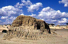
| Erosion cuts into the
sand dune, Lake Mungo National Park
|
Lake Mungo
Archaeologically significant part of the Willandra Lakes
World Heritage Area
Located 987 km west of Sydney via the Hume and Sturt
Highways and 128 km north of Balranald, Mungo National Park
is a 27847-ha archaeological and geomorphological site of
world importance. Lake Mungo is one of 17 dry lakes which
constitute the Willandra Lakes World Heritage Area, declared
in 1981. The stark, silent, desolate and sometimes eerie
landscape of sand, sparse but resurgent vegetation, and
spiny, hard, pitted, crinkled and fluted dunes and ridges
can look more like a moonscape.
25 000 to 45 000 years ago the lake covered 135 square
kilometres and was about 10 m deep. It was one of a series
of freshwater lakes along Willandra Creek, which was then a
major branch of the Lachlan River. The lakes dried up about
14 000 years ago. They are, however, an extraordinarily rich
source of fossils. Indeed the quality and quantity of
evidence pertaining to the landforms, animal life and
environmental conditions during the last ice age are of the
highest calibre, in part due to the alkaline rather than
acidic quality of the soils.
The remains of extinct creatures - Tasmanian tigers,
giant, short-faced kangaroos and a strange oxen-sized animal
called a zygomaturus - have been found. Crucially, carbon
dating has indicated that Aborigines inhabited the area 40
000 years ago, making it the site of the oldest known human
occupation in Australia. From the lake they gathered
mussels, Murray cod and golden perch. They also hunted
wallabies and rat kangaroos and collected emu eggs.
Findings of ochre in the area, dating back 32 000 years,
constitute the earliest evidence in the Pacific Basin of the
deliberate selection of pigments. As there was no local
source it has been deduced that the material was carried
there for aesthetic purposes. Moreover, a 28 000-30
000-year-old burial site reveals that the body was covered
in red ochre. A 26 000-year-old grave contains the earliest
known human example of cremation. After the ritual
incineration the bones were smashed and deposited in a hole
by the pyre. These practices clearly suggest the presence of
spiritual considerations.
Convex flake tools made from local material dating back
20 000 years have been found, while sandstone grinders from
10 000 BP (before the present) or earlier suggest the
inhabitants adapted to the arid conditions which later
prevailed by grinding wild grass seeds, making them among
the first people in the world to grind flour. The sandstone
came from at least 100 km away, suggesting patterns of
seasonal migration. A number of the finds indicate practices
parallel with recent Tasmanian Aborigines.
Prior to being declared a National Park in 1979 this land
was part of Mungo sheep station, created when the Gol-Gol
station was subdivided in the 1920s for returned soldiers.
It was named by the Cameron Brothers after a picture they
saw of St Mungo's Church in Scotland. The park still
contains a 45-m woolshed, built by Chinese labour of local
pine logs in 1869. There are other buildings, including a
former homestead, relating to the sheep station. Squatters
first arrived with their sheep in 1840. Considerable
conflict ensued with the indigenous tribes - the Barkindji,
Ngiyampaa and Mutthi Mutthi, descendants of the area's
ancient inhabitants. However, many were decimated by
European diseases and forced to live on a mission at
Balranald. Today they are involved in the management of the
park and their wishes concerning the handling of their dead
ancestors are now respected.
Today the vegetated dry lake basins are situated within a
dunefield stabilised by mallee-type vegetation. Tall, steep
escarpments abut the western perimeters of the lakes with
crescent-shaped dunes called lunettes to the east, formed by
quartz sands and pelletised clay, blown from the lake by the
westerly winds. The most famous example of a lunette in the
park is the the 'Walls of China' which rises to 30 m above
the plain and runs for some 30 km around the old lake's
eastern shore.
The area has been relatively free of clearing and pasture
improvement although introduced animals destroyed the native
vegetation, particularly along the Walls of China.
Ironically it is this stripping of the flora which exposed
the dune's top soil to erosion and hence uncovered the
archaeological finds. Today the pre-European vegetation is
returning. Birdlife is increasing, particularly pink
cockatoos and chats and the striking mulga parrot. There are
also kangaroos, emus and plenty of lizards.
Things to see:
![[Top of page]](smlArrow.gif)
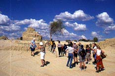
|
| Tour group listening to
Graham Clarke from Harry Nanya Tours near the Walls
of China sand dune |
Visiting the Park
The park's visitor's centre, open every day, is located near
the park entrance. It has extensive displays of local
Aboriginal culture and of the area's geomorphology and
archaeology, plus an audio-visual room. There are two
camping areas, as well as self-contained accommodation in
the old shearer's quarters for groups of up to 24. There are
barbecues, a picnic area, pit toilets and tank water. Tours
of the Walls of China are conducted by rangers in the school
holidays. The Grasslands Nature Walk (1 km) is a signposted
track suitable for wheelchairs. The Foreshore Walk (2.5 km)
starts adjacent the visitor's centre.
There is also a 65-km, self-drive tour through the park,
easily managed by family cars. It includes 15 stops, each
with signposted information. It takes you to the Mungo
woolshed, the Walls of China, the 'Grand Canyon', Belah
campground, an old squatter's hut, the remnants of Cobb and
Co. coach tracks at Vigars Wells where the teams stopped for
water, the viewing area at Lake Leaghur and the ruins of
Zanci station.
The park entrance is off the road which runs along the
western boundary of the park. It can be accessed from a
number of different directions. From Mildura take the road
to Wentworth and just past the Buronga limits turn rignt
into Arumpo Rd (unsealed) and follow the signposts.
Alternatively head north from Balranald via Penarie and
Bidura. Or you can take one of two turnoffs from the
Wentworth-Pooncarie road.

Broadwalk
Business Brokers
Broadwalk Business
Brokers specialise in General Businesses for Sale, Caravan Parks for
Sale, Motels for Sale, Management Rights & Resorts for Sale, Farms for
Sale, Hotels for sale,Commercial & Industrial Properties for Sale.
Phone:
1300 136 559
Email:
enquiries@broadwalkbusinessbrokers.com.au
AUSTRALIAN BUSINESSES FOR SALE
COFFS HARBOUR BUSINESS BROKERS
BROADWALK BUSINESS BROKERS
GOLD COAST BUSINESSES FOR SALE
BRISBANE BUSINESSES FOR SALE
SYDNEY BUSINESSES FOR SALE
CARAVAN PARKS FOR SALE
BUSINESSES FOR SALE
MOTELS
FOR SALE
HOTELS
FOR SALE
Disclaimer
We advise prospective purchasers that we take no
responsibility for the accuracy of any information in the business
provided by vendors or their professional advisers and that they should
make their own enquiries as to the accuracy of this information,
including obtaining independent legal and/or accounting advice
Lake Mungo