|
| Fishing at Laurieton
|
Laurieton
Pleasant holiday destination on the Mid-North Coast.
Located 380 km north of Sydney via the Pacific Highway,
Laurieton is now part of the holiday/urban development along
the coast to the south of Port Macquarie. This inevitable
coastal development, which spreads through Lake Cathie,
Bonny Hills and North Haven, means that it is quite
difficult to determine the actual limits of Laurieton. This
is explained by the fact that Laurieton is one of the seven
towns and villages which form the Camden Haven. The others
are North Haven, Dunbogan, Bonny Hills, Kew, Kendall and
Comboyne. Each of these towns and villages lies adjacent to
the Camden Haven River.
The town is scenically located at the base of North
Brother Mountain at the mouth of the Camden Haven River. The
result is a setting which combines lagoons and waterways
with bushland and some unique views of the Mid-North Coast.
The region had been settled by the Gadang Aborigines for
tens of thousands of years before Captain James Cook sailed
up the coast in 1770. Impressed by the three mountains he
could see from his ship, Cook named them 'The Brothers'. The
most impressive, rising to 490 metres, is North Brother.
The first European into the area was the explorer John
Oxley who named the inlet Camden Haven in 1818. He also
named Watson Taylor Lake after a British MP who had been
influential supporting the pastoralist and landowner John
Macarthur.
Today the area is a peaceful, attractive and
under-developed holiday destination.
Things to see:
![[Top of page]](smlArrow.gif)
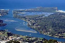
|
| The view from the Camden
Haven Lookout looking down on Camden Haven and
Laurieton |
North Brother Lookout
Don't miss it. It is 5km up on the Captain Cook Bicentenary
Road which is unsuitable for caravans. It is unsuitable for
caravans. The summit of North Brother Mountain (490 metres)
offers a superb view over the coastline, the lakes and the
mouth of the Camden Haven River. It is one of Australia's
most impressive coastal panoramas. The area is characterised
by large stands of rainforest which is rich in native fauna
and flora. Head west along Kew Rd then take the signposted
turnoff on the left and follow the winding road to the
summit.
Queens Lake and Camden Haven River
Laurieton is really about water activities and the lake and
river provide plenty of opportunity for fishing, boating and
walking along the foreshores.
Crowdy Bay National Park
Take the road from Laurieton heading south and you will
enter the northern section of Crowdy Bay National Park. The
entrance from the south is via Moorland which is north of
Coopernook. Both roads are unsealed.
This area of parkland was first sighted by Captain Cook
in 1770. He saw Aborigines standing on what is now known as
Diamond Head and named the promontory Indian Head.
In more recent times a man named Ernie Metcalf lived on
the headland. He was the subject of 'The Man on the
Headland' written by Kylie Tennant. He built a hut for
Tennant who subsequently gifted it to the park. It was
restored in 1980 and is now one of the park's attractions.
Diamond Head itself is quite striking. It rises 113
metres and is edged by the wetlands and heathlands of the
coastal plain. The park is ideal for bushwalking,
birdwatching, fishing (from the rock platforms you can catch
groper, bream, tailor and drummer) and swimming.
There are three popular walks:
1. The Cliff Base Walk - a walk around the base of
Diamond Head on the rock platform with its myriad sea life.
2. Diamond Head Loop Track - 4.8 km long and comfortably
achieved in 2 1/2 hours this track offers spectacular views
and passes through a wide range of flora from littoral
rainforest to casaurina woodland and heathlands. Look out
for the small and carnivorous droseras or sundews.
3. Kylie's Hut - this is the shorter loop walk to the hut
built for Kylie Tennant.
N.B. There is no reliable fresh water in the park.
Kattang Nature Reserve
This is a small, 58 hectare reserve located 3 km east of
Laurieton which is the direct result of the local
community's 'Save the Heathland' campaign. It has been
listed on the National Estate and is an ideal place for
bushwalking, birdwatching and fishing. There are a number of
walking tracks (the NPWS provides a brochure with a good
map) from Bergalia (at the end of Camden Haven Road) and
Hamey (at the end of the Charles Harney Lookout Road)
carparks.
There is (a) the Camden Head Lookout walk (b) the 'Flower
Bowl' walk which lies among elevated sand dunes and offers
marvellous displays of wildflowers in spring (c) the
Perpendicular Point Walk which provides excellent views back
on the Camden Haven estuary and (d) the short side walks
down to Fishermans Bluff and Pebbly Beach.
The area, although small, is noted for its flora and
fauna. Over 100 species of bird have been recorded in the
park and there are small areas of rainforest and pockets of
flannel flowers and everlasting daisies.

Broadwalk
Business Brokers
Broadwalk Business
Brokers specialise in General Businesses for Sale, Caravan Parks for
Sale, Motels for Sale, Management Rights & Resorts for Sale, Farms for
Sale, Hotels for sale,Commercial & Industrial Properties for Sale.
Phone:
1300 136 559
Email:
enquiries@broadwalkbusinessbrokers.com.au
AUSTRALIAN BUSINESSES FOR SALE
COFFS HARBOUR BUSINESS BROKERS
BROADWALK BUSINESS BROKERS
GOLD COAST BUSINESSES FOR SALE
BRISBANE BUSINESSES FOR SALE
SYDNEY BUSINESSES FOR SALE
CARAVAN PARKS FOR SALE
BUSINESSES FOR SALE
MOTELS
FOR SALE
HOTELS
FOR SALE
Disclaimer
We advise prospective purchasers that we take no
responsibility for the accuracy of any information in the business
provided by vendors or their professional advisers and that they should
make their own enquiries as to the accuracy of this information,
including obtaining independent legal and/or accounting advice
Laurieton