|
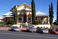
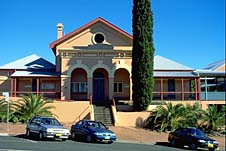
| The Court House
|
Lismore (including Clunes, Bentley, Alphadale,
Bexhill, Eltham and The Channon)
Major commercial, cultural and educational centre on the
far north coast of New South Wales.
Located 776 km north-east of Sydney via
Woodburn, Lismore is a prosperous, substantial and quite
cosmopolitan city of 43 000 people. These attributes stem
largely from the fact that it is the major commercial and
administrative city on the state's North Coast, although the
city itself is actually located in an attractive rural
riverside setting about 30 km inland.
The area around Lismore has become a major base for those
wishing to pursue creative endeavours and alternative
lifestyles. Thus there is a high concentration of painters,
woodworkers, ceramists, filmmakers, musicians, poets,
designers and dancers. Consequently, there are many
galleries, studios and theatres in the area.
The beauty of the environment has made Lismore a base for
those wishing to explore the surrounding area. Hence tourism
is an asset to the local economy. The district is one of the
country's most closely settled rural areas and one of the
principal dairying regions in the state. Other contributions
to the local economy are made by pig farming, bacon-curing,
the production of bananas, tropical fruit, macadamias and
sugar, as well as sawmilling, engineering, steel
fabrication, brewing and clothing manufacture. Being located
on the Bruxner Highway, it is also a centre for road
transport .
Lismore lies nine metres above sea-level on the narrow
and winding North Arm of the Richmond River, although this
branch of the waterway was renamed Wilsons River in 1976 in
honour of the family who established the 'Lismore' station.
In 1828 Captain Henry Rous became the first European to
encounter the river which he named the Richmond after a
family friend - Charles, the Fifth Duke of Richmond. He
followed the river upstream for about 32 km noting numerous
Aborigines, 'flat open forest on the western bank and thick
jungle to the eastward with fine timber'. Rous's endeavours
were part of a general exploration of the land north of
Sydney undertaken in the 1820s as drought and an expanding
population created a demand for new pasturage.
The first station on the future townsite was probably
established in 1842 as there were reports of a shepherd and
10 000 sheep on the site (sheep did poorly in the heat and
moisture of the valley and were soon replaced by cattle). It
was located at the western edge of a dense forest area of
around 75 000 ha known to whites as the 'Big Scrub' which is
thought to have been the largest stand of subtropical
rainforest in the world. The Bundjalung Aborigines called
the area 'Tchukarmboli' or 'Tuckurimba'.
Scotsman William Wilson then took up the rights to the
run and was in occupation of the land by 1845 (his cottage
stood at what is now the southern end of Molesworth St). The
Wilsons named the property 'Lismore' after the island of
Lismore in Argyllshire, Scotland which they visited on their
honeymoon. It remained a station until 1855 when a townsite
was surveyed on what had been the Wilsons' house paddock.
The first hotel was in existence by the end of 1855. The
village of Lismore was gazetted in 1856 and the first land
sale took place later in the year. The first store was
opened in 1857. Wilson bought many of the allotments himself
although station hands and timber-workers also invested.
|
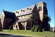
| St Carthage's Catholic
Church, Lismore |
The timbergetters, upon the advice of local Aborigines,
had arrived in the valley by 1842, by which time the cedar
along the Clarence River had begun to disappear. There they
found a seeming utopia of cedar and the Richmond Valley was,
by the start of the 1850s, the major source of timber for
the Sydney and Melbourne markets. A sawmill was established
in South Lismore in 1855 but it soon failed. However, as
Lismore represented the head of navigation on the North Arm,
cedar-cutters upstream floated the timber to this point
where it was picked up by river craft. Other more successful
mills were set up from the 1880s.
The growth of the logging industry in the 1850s and 1860s
prompted a considerable increase of river traffic which in
turn would prove highly beneficial to the growth of Lismore.
The river trade continued quite profitably until after World
War II when it was rendered redundant by rail and road
improvements.
A school appears to have been opened in 1862 but a
contemporary account noted that the population of Lismore
remained 'small and scattered' in the 1860s. However, free
selectors had begun to trickle in. They cleared the 'Big
Scrub' and established farms. Corn-growing proved a failure
and sugarcane was taken up in the late 1860s. However, it
was not until the Colonial Sugar Refining Company opened a
large crushing mill in 1881 at Broadwater, buying cane on
contract from farmers, that consistent success was achieved.
Potatoes, maize, bananas and livestock were also cultivated.
Dairying started on a very tentative basis as there was a
lack of good grass for cattle. An influx of experienced
dairy farmers from the South Coast in the 1880s proved
beneficial although the enormous success of local dairying
is attributable, in large part, to the introduction of
paspalum grass in the 1890s.
Free selectors began to arrive in far greater numbers in
the late 1870s and Lismore became a municipality in 1879.
Closer settlement led to the establishment of an Anglican
Church (work commenced in 1871), a Catholic Church
(completed in 1877), the first bank (1875), a newspaper, the
Northern Star (in 1876), a courthouse (1877-78), a
Presbyterian Church (1881) and two private schools. The
1880s witnessed the population surpass 1000, bridges built
to replace ferry punts, the construction of the first
permanent post office, the council chambers and a cottage
hospital, and the introduction of gas lighting and a water
supply system. By the time Lismore was linked by rail to
Murwillumbah, in 1894, the town had become the main business
centre on the river. Lismore became a city in 1946.
The Lantern Parade (a major community celebration) is
held late in June each year and, in October, there is a folk
festival and the North Coast National Show. Markets are held
on the first and third Sunday of the month at Lismore
Shopping Square.
Things to see:
![[Top of page]](smlArrow.gif)
Tourist Information
The Lismore Visitor and Heritage Centre is located at the
corner of the Bruxner Highway and Molesworth St. It features
the 'Rainforest Experience' - a rather elaborate and quite
authentic-looking indoor recreation of a rainforest
environment complete with sound effects, button-operated
animals, a waterfall, a bridge, separate video displays
demonstrating what is happening on the ground, the middle
and the canopy of a rainforest, a section on the history of
the area and a large gallery of local arts and crafts for
which the area is noted. Enquiries can also be made here
concerning self-drive tours around the area, tel: (02) 6622
0122.
Nearby Heritage Park has free barbecue facilities, a
playground and miniature train rides.
Cedar Log Memorial
Nearby, in Ballina St, is a small park adjacent the city
hall which is home to the Cedar Log Memorial. This 16-metre
log is a reminder of the magnificent timber that once
festooned the entire valley. Ironically it is intended as a
tribute to the cedargetters who chopped it down.
Museum
Proceed up Molesworth St. To the left, at no.165, are the
old council chambers. Upstairs is the Richmond River
Historical Society Museum which features some fine colonial
furniture made of local cedar and other pioneering relics,
geological specimens, Aboriginal artefacts and a
photographic collection. They are open weekdays from 10.00
a.m. to 4.00 p.m., tel: (02) 6621 9993. This building is
located on the edge of attractive Spinks Park which
overlooks Wilsons River.
Art Gallery
A little further along Molesworth St, at the Magellan St
corner, is the Lismore Regional Art Gallery, tel: (02) 6622
2209.
Post Office
Opposite the museum is W.L. Vernon's excellent Art Nouveau
post office (1897) with its fine brickwork, sandstone
masonry, fretwork cupola and massive tower. Its location is
a reminder of the river's centrality to the development of
the city.
Proceed north along Molesworth St for one block. The T &
G Building, at the Woodlark St corner, was built in 1891 to
an Italian villa style by the Australian Joint Stock Bank.
|
| The Court House
|
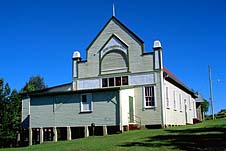
Courthouse
Proceed along Molesworth St for another block and turn right
into Zadoc St. The imposing Classical Revival courthouse
(1883), with its grand stairway, makes an impressive
contribution to the streetscape.
Churches
Opposite is St Andrew's Anglican Church (1904 with additions
in 1913 and 1935) which overlooks the river. It replaced the
original timber church (1871).
Turn right into Keen St then, at its end, turn right into
Orion St. At the Leycester St corner is St Carthage's Roman
Catholic Cathedral (1892-1907) which has some fine woodwork
and stained-glass work and a rich interior.
Return to Keen St. At the corner of Keen and Woodlark St
is the Uniting (formerly Methodist) Church (1908-09) and at
Keen and Magellan is the 'Byzantine-inspired' Church of
Christ (1923). At Keen and Conway is St Paul's Presbyterian
Church (1907-08) which replaced an 1881 original.
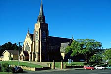
|
| St Andrews Anglican
Church |
Rotary Park
In Rotary Park, a rainforest tract (a small remnant of the
'Big Scrub') has been regenerated in the middle of the city.
There are 3 km of pathways with rare species of rainforest
plants clearly marked. A brochure is available from the
information centre. To get there follow Ballina St (the
Bruxner Highway) east of the information centre for 3.5 km
and turn left at the roundabout into Rotary Drive.
Claude Riley Memorial Lookout
The next left at the same roundabout leads into New Ballina
Rd. Along here, to the left, is the Claude Riley Memorial
Lookout which overlooks the town's residential districts.
Lismore Lake
Lismore Lake, 2.5 km south of the CBD on the eastern side of
Union St (the south-bound leg of the Bruxner Highway), is a
pleasant 14-ha artificial lagoon for swimming with
picnic-barbecue facilities and an adventure park on the
foreshores.
Robinsons Lookout
Robinsons Lookout on Girards Hill offers views west over the
river to South Lismore and north over the town to Blue Knob,
Mt Nardi and Mt Matheson. Turn south off Ballina St (the
eastbound leg of the Bruxner Highway) into Wyrallah St.
After 500 m turn right into Esmonde St then take the third
left into Robinsons Rd.
Wilsons Park
Also along Wyrallah St (2 km from Ballina St), on the
western side of the road, is Wilsons Park which contains a
remnant of the area's original rainforest vegetation. The
rainforest trees are labelled.
Bora Ring
Wyrallah St heads southwards out of Lismore towards
Woodburn. 12 km from Lismore is the village of Wyrallah.
Just to its south there is a signposted turnoff on the left
to an excellent example of an Aboriginal bora ring: a
circular cleared area measuring 22 metres in diameter is
bounded by a bank of earth forming a ceremonial site. The
ring overlooks the Steve King's Plain and a portion of the
Richmond Valley. There is an information board at the site
which lies to the rear of the Tucki Tucki village cemetery.
Tucki Tucki Koala Reserve
A few kilometres further south, adjacent the Wyrallah Rd (15
km from Lismore) is Tucki Tucki Koala Reserve (4 ha). It was
established by local residents to preserve a habitat for the
disappearing marsupials. There are picnic tables and a
short, graded walking track steers you in the right
direction.
Victoria Park
Victoria Park Nature Reserve (16 km south-east) represents
an 18-hectare remnant of the 'Big Scrub'. Head south off the
Bruxner Highway into Rous Rd at the eastern edge of Lismore
and follow the signs for Tregeagle then Rous Mill (which is
a place and not a mill) then Wardell. There is all-vehicles
access, a walking track from the carpark, a boardwalk for
those with disabilities, an information bay, tables,
fireplaces, toilets, water and shelter.
Alphadale
11 km east at the corner of the Bruxner Highway and Cowlong
Rd, Alphadale, has a number of arts and crafts studios and
the tone of the town is shaped by the alternative lifestyles
of the surrounding communities.
Boatharbour Nature Reserve
Boatharbour Nature Reserve, 6 km north-east of the CBD along
the Bangalow Rd, has a resident bat colony. This was a base
camp for timbergetters working in the 'Big Scrub' in the
late 19th century. A paved track leads to a viewing platform
overlooking the river. There are barbecue facilities.
Bexhill
Bexhill (initially the Bald Hill cedar camp) is located 9 km
north-east of Lismore along the Bangalow Road. It was a more
important settlement than Lismore in the 1850s. The hall and
public school are of interest.
Turn right in front of the post office across the bridge
and then immediately left up a steep hill to Inspiration
Point which offers fine views of the Corndale Valley. There
you will find the Open Air Cathedral with its stone altar,
log pews and cross. It was created by the Bexhill Youth
Fellowship in 1958. Below the point is the well-attended
Bexhill Church (1926) which boasts an organ that draws
players from as far afield as Sydney and Brisbane to its
recitals.
Eltham
Another 2 km along the same road is a turnoff on the right
to the small village of Eltham which has some interesting
old buildings such as the hotel, St Mark's Anglican Church
and the masonic temple on the hill to its rear. A left turn
near the church leads back to the main road. A right turn
leads to Clunes.
|
| Clunes Coronation Hall
|
Clunes
Clunes is a small village located 7 km north-east of Bexhill
along the Bangalow Rd. In 1892, Clunes was the meeting place
for a group of dairy farmers who went on to establish the
North Coast Dairying Co-operative, or Norco as it is more
familiarly known. This was a major event in local history as
dairying would become the dominant industry in the area in
the 20th century.
The through-road leads past St John's Presbyterian Church
(1910) on the left and St Peter's Anglican Church (1906) on
the right. After the latter, take the next sharp left to see
the Methodist (now Uniting) Church and manse. Opposite is
the Coronation Hall (1910).
The Channon
The Channon is a pretty village perched on a hilltop which
is noted for its artistic alternative community. The premier
markets in the area are held at Coronation Park on the
second Sunday of each month. They are an ideal place to
check out the rich arts and crafts of the area. Opera at The
Channon is a black-tie event held on the first of August.
The village is named after a local palm, the sight of which,
it is believed, helped Aborigines navigate their way from
the coast. It has a tavern and camping grounds.
To get there head out of Lismore on Dunoon Rd and follow
it for about 14 km. About 3 km before you reach Dunoon turn
left for The Channon.
Nightcap National Park
If you turn right at The Channon onto Terania Creek Rd
(unsealed, narrow and rough for large vehicles) it leads,
after 9.5 km, to the Protester Falls Picnic Area which is
located in the Terania Creek basin - a narrow valley of
subtropical rainforest and eucalypt forest at the foot of
the Nightcap Range in the eastern section of Nightcap
National Park. There are two causeways en route so be
careful in wet weather.
At the picnic area there is a turning circle set within a
glade of the rainforest. It is a 1.4-km return walk to
Protesters Falls which is set amidst beautiful rainforest
featuring dense thickets of bangalow palms. The falls were
named after the protesters who carried on an anti-logging
campaign here in the late 1970s and early 1980s which led to
the declaration of the national park in 1983. Another walk
follows an old logging track adjacent Terania Creek.
The ridges, peaks and gullies of Nightcap National Park
(4945 ha) consist of solidified and eroded lava from the
extinct Mt Warning volcano which once covered 4000 square
kilometres from Coraki in the south to Beenleigh in the
north, from Kyogle in the west to the volcanic reefs in the
ocean to the east. The fertile soil which derived from the
igneous rock, together with the state's highest rainfall,
have created one of the state's finest sections of
subtropical rainforest. Some of the park's enormous brush
box are thought to be up to 1500 years old. The park is also
of spiritual importance to the Bundjalung Aboriginal people
and is now World Heritage listed. For further information
ring (02) 6672 6360 on weekdays.
Dunoon and Rocky Creek Dam
Dunoon is located 17 km north-north-east of Lismore along
Dunoon Rd (3 km beyond the turnoff to The Channon) and is
noted for its macadamia plantations and orchids. On the
left, as you enter town, is St Andrew's Presbyterian Church.
The second road on the left (a 3-km strip of bitumen and
gravel) leads to the Rocky Creek Dam Picnic Area which
overlooks the lake with its mountainous background. As Rocky
Creek is the main water supply for Lismore, fishing,
swimming and boating are prohibited. There are
picnic-barbecue facilities with wood supplied, a shelter
shed, a playground, drinking water and walking tracks. A
boardwalk leads by Platypus Lagoon.
Whian Whian State Forest
Rocky Creek Dam is located within Whian Whian State Forest
which is traversed by an enjoyable 30-km loop drive that
starts at Minyon Falls and finishes near the Rocky Creek Dam
Picnic Area. Guiding leaflets are available from the Lismore
Information Centre.
To get to the start of the drive, follow the main road
through Dunoon, past the turnoff to the Rocky Creek Dam
Picnic Area and simply follow the signs for Minyon Falls.
About 2 km before you reach the falls, Minyon Drive will
take you past the Minyon Grass Picnic Area. A 2-km walking
track leads to the base of the falls. Alternatively,
continue in your car along Minyon Drive to a picnic area and
recreation site by the falls which tumble 97 m down sheer
cliffs, formed by solidified lava, into the beautiful gorge
below. They are part of the Minyon Falls Flora Reserve which
has been exempted from all logging due to its high
recreational, scenic and scientific value. A board in the
picnic area indicates the whereabouts of a nearby
walking-trail complex. The departure track, which takes in a
lookout over Minyon Falls, follows the rim of the escarpment
for about 2 km around to Quandong Falls. From this point you
can return to the picnic area or continue on for another 2
km to the valley floor at the base of the falls. Its quite
easy going down but a steep walk back.
Return to your car. Follow the main forest drive then
turn right at Peates Mountain Road. 200 m will bring you to
Rummery Park, a grassy clearing amidst regrowth forest where
koalas live. There are picnic and camping facilities. A
relatively easy 3-km walking track leads to Peates Mountain
Lookout. The Boggy Creek Track (2 km) and Eastern Boundary
Track (2.5 km) both lead back to the Minyon Falls Picnic
Area.
For those who wish to stick to their cars, continue along
Peates Mountain Road. 3.5 km beyond Rummery Park is a
signposted turnoff to a parking area and it is a 10-minute
walk to Peates Mountain Lookout (600 m) which offers views
southwards over rich farmlands to Lismore, northwards to Mt
Warning and east to Byron Bay.
Return along Peates Mountain Road to the main forest
drive which continues westwards through blackbutt and
flooded gum plantations, across Rocky Creek, past the
Gibbergunyah Roadside Reserve and, in the final 2 km,
through the Big Scrub Flora Reserve which is the largest
surviving remnant of the 'Big Scrub'.
The forest road reaches a T-intersection with the sealed
council road that leads to Rocky Creek Dam Picnic Area. Turn
right along this road, then right at the T-intersection to
return to Lismore, via Dunoon.
Bentley
Bentley, 23 km north-west of Lismore along the Kyogle Road,
is noted for the Bentley Art Prize, a substantial award
which has a strong Aboriginal art section.
Bentley House was established in the 1870s by Robert
Dawson who was born at Great Bentley in England

Broadwalk
Business Brokers
Broadwalk Business
Brokers specialise in General Businesses for Sale, Caravan Parks for
Sale, Motels for Sale, Management Rights & Resorts for Sale, Farms for
Sale, Hotels for sale,Commercial & Industrial Properties for Sale.
Phone:
1300 136 559
Email:
enquiries@broadwalkbusinessbrokers.com.au
AUSTRALIAN BUSINESSES FOR SALE
COFFS HARBOUR BUSINESS BROKERS
BROADWALK BUSINESS BROKERS
GOLD COAST BUSINESSES FOR SALE
BRISBANE BUSINESSES FOR SALE
SYDNEY BUSINESSES FOR SALE
CARAVAN PARKS FOR SALE
BUSINESSES FOR SALE
MOTELS
FOR SALE
HOTELS
FOR SALE
Disclaimer
We advise prospective purchasers that we take no
responsibility for the accuracy of any information in the business
provided by vendors or their professional advisers and that they should
make their own enquiries as to the accuracy of this information,
including obtaining independent legal and/or accounting advice
Lismore