|
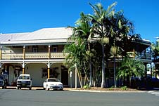
| Palm trees and the
Commercial Hotel in the main street
|
Mullumbimby
Famous hippie township which mixes mainstream and
alternative lifestyles.
Mullumbimby is a quiet country township which was once a
rural centre servicing the surrounding farms. In the late
1960s it became one of the great alternative lifestyle
centres in the country. It carries this reputation with much
more confidence than its more famous partner, Nimbin, which
is only a short distance away.
In the lexicon of names which can be used to conjure up
images of hippies and psychedelic colours Mullumbimby is
second only to Nimbin. Ironically today the town bears few
signs of the lifestyle which invaded it in the early 1970s.
There are no brightly-coloured shop fronts like Nimbin;
there are no young kids up from Sydney looking for drugs and
fun.
Mullumbimby is located 4 km off the Pacific Highway, 798
km north-east of Sydney, 19 km north-west of
Byron Bay and 165 km south of Brisbane. It is situated
on the Brunswick River at 4 metres above sea-level and had a
population, in 1996, of 2870 people. Tourism is important to
the local economy in a region which is noted for its
production of bananas, avocados, pineapples and other
tropical fruit, dairy products, macadamia nuts, cattle, pigs
and timber.
The town's name is thought to derive from the language of
the Bundjalung people with 'muli' said to mean 'hill'. The
full name has been interpreted as meaning 'small round hill'
- a reference to Mt Chincogan (309 m), beneath which the
town is situated.
The first European to explore the Brunswick River was
Captain Henry Rous, in 1828. He named it after the wife of
George IV - Queen Caroline of Brunswick. Timbergetters
exploited the trees along the riverbanks from the 1850s and
a townsite was reserved in 1872 near a river crossing. A
school opened in 1886 to serve local families. The townsite
was surveyed in 1887 and the village was proclaimed the
following year. A post office opened in 1889. When the
railway arrived in 1894 dairying and agriculture took off
and the town prospered, acquiring its own municipal
government in 1908. The fertile river flats and subtropical
climate also proved ideal for the cultivation of bananas and
other tropical fruits.
|
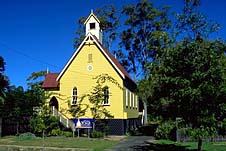
| The Yellow Church Yoga
and Natural Therapy Centre |
A weir was built on Wilsons Creek in the 1920s. It
supplied both the town's water supply and a hydro-electric
power station which also serviced Bangalow and Byron Bay.
The Mullumbimby Chincogan Fiesta, held each year in
September, centres on a foot-race from the post office to
the top of Mt Chincogan and back. The Mullumbimby markets
are held in the reserve behind the Stuart Street Museum on
the third Saturday of the month.
Things to see:
![[Top of page]](smlArrow.gif)
Museum
Brunswick Valley Historical Society Museum is located in the
former post office (1907) at the southern end of Stuart St,
bordering Saltwater Creek. It is open on Friday from 11.00am
- 3.00pm, on market days (3rd Saturday of each month), and
at other times by arrangement.
Cedar House
Cedar House (1908), at 1 Dalley St, has been restored and,
at its rear, is an antiques gallery. Other Dalley St
buildings of some historic interest are the police station
and courthouse (1908), both designed by W.L. Vernon and
located near the corner with Burringbar St.
Brunswick Valley Heritage Park
There is a walking track through Brunswick Valley Heritage
Park - a reserve where over 200 rainforest plants have been
established and labelled. They include red cedars,
coolamons, grevilleas, black apple, giant water gum,
rosewood, flooded gum, swamp mahogany and hoop pines It is
located at the corner of Tyagarah St and Brunswick Terrace,
adjacent the river. There is an accompanying pamphlet which
you should be able to obtain from the Lyrebird Motel. The
latter functions as something of a local information centre.
Walking Trails
In Burringbar St, behind the post office, a noticeboard
outlines the course of six walking trails. The longest leads
to Pioneer Lookout (2 km).
Pioneer Lookout
There is a lookout off Azalea St, at the south-western
corner of town.
Crystal Castle
Crystal Castle is located 7 km south-west of town. This fine
building is perched on a hillside offering lovely views
through French windows. Housed within is a display (said to
be Australia's largest) of natural crystals - violet
amethyst, clear and rose quartz, banded agate etc - in
various forms - natural and artificial.
To get there, head south along Dalley St, turn right into
Jubilee Ave and follow it out of town as it passes the golf
course and winds up into the hills. When you reach the fork
at the top of the hill, keep to the right. You will soon see
Monet Drive on your right. Turn here and look to the left.
It is open daily from 10.00 a.m. to 4.30 p.m., tel: (02)
6684 3111.
Whian Whian State Forest
To get to Minyon Falls and Whian Whian State Forest, return
along Monet Drive to the main road and turn right. Follow
this road through Goonengerry. After about 8 km there is a
right turn, signposted for Minyon Falls. After about four
more kilometres there is another signposted turnoff on the
right, into Minyon Drive (a map of the area would be
helpful).
About 2 km before you reach the falls, Minyon Drive will
take you past the Minyon Grass Picnic Area. A 2-km walking
track leads to the base of the falls. Alternatively,
continue in your car along Minyon Drive to a picnic area and
recreation site by the falls which tumble 97 m down sheer
cliffs, formed by solidified lava, into the beautiful gorge
below. They are part of the Minyon Falls Flora Reserve which
has been exempted from all logging due to its high
recreational, scenic and scientific value. A board in the
picnic area indicates the whereabouts of a nearby
walking-trail complex. The departure track, which takes in a
lookout over Minyon Falls, follows the rim of the escarpment
for about 2 km around to Quandong Falls. From this point you
can return to the picnic area or continue on for another 2
km to the valley floor at the base of the falls. Its quite
easy going down but a steep walk back.
Return to your car. Follow the main forest drive then
turn right at Peates Mountain Road. 200 m will bring you to
Rummery Park, a grassy clearing amidst regrowth forest where
koalas live. There are picnic and camping facilities. A
relatively easy 3-km walking track leads to Peates Mountain
Lookout. The Boggy Creek Track (2 km) and Eastern Boundary
Track (2.5 km) both lead back to the Minyon Falls Picnic
Area.
For those who wish to stick to their cars, continue along
Peates Mountain Road. 3.5 km beyond Rummery Park is a
signposted turnoff to a parking area and it is a 10-minute
walk to Peates Mountain Lookout (600 m) which offers views
southwards over rich farmlands to Lismore, northwards to Mt
Warning and east to Byron Bay.
Return along Peates Mountain Road to the main forest
drive which continues westwards through blackbutt and
flooded gum plantations, across Rocky Creek, past the
Gibbergunyah Roadside Reserve and, in the final 2 km,
through the Big Scrub Flora Reserve which is the largest
surviving remnant of the 'Big Scrub'.
The forest road reaches a T-intersection with a sealed
road. A left turn leads directly to Rocky Creek Dam Picnic
Area. However, if you wish to return to Mullumbimby, turn
right at the sealed road then, at the next T-intersection,
turn left.
Rocky Creek Dam Picnic Area
Rocky Creek Dam Picnic Area (see previous entry for
directions) overlooks the associated lake with its
mountainous background. As Rocky Creek is the main water
supply for Lismore, fishing, swimming and boating are
prohibited. There are picnic-barbecue facilities with wood
supplied, a shelter shed, a playground, drinking water and
walking tracks. A boardwalk leads by Platypus Lagoon.
Wanganui Gorge
Wanganui Gorge and Rainforest Track is 20 km west of
Mullumbimby.

Broadwalk
Business Brokers
Broadwalk Business
Brokers specialise in General Businesses for Sale, Caravan Parks for
Sale, Motels for Sale, Management Rights & Resorts for Sale, Farms for
Sale, Hotels for sale,Commercial & Industrial Properties for Sale.
Phone:
1300 136 559
Email:
enquiries@broadwalkbusinessbrokers.com.au
AUSTRALIAN BUSINESSES FOR SALE
COFFS HARBOUR BUSINESS BROKERS
BROADWALK BUSINESS BROKERS
GOLD COAST BUSINESSES FOR SALE
BRISBANE BUSINESSES FOR SALE
SYDNEY BUSINESSES FOR SALE
CARAVAN PARKS FOR SALE
BUSINESSES FOR SALE
MOTELS
FOR SALE
HOTELS
FOR SALE
Disclaimer
We advise prospective purchasers that we take no
responsibility for the accuracy of any information in the business
provided by vendors or their professional advisers and that they should
make their own enquiries as to the accuracy of this information,
including obtaining independent legal and/or accounting advice
Mullumbimby