|
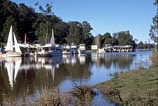
| Houseboats at Bulahdelah
- a popular entry to the Myall Lakes
|
Myall Lakes
Beautiful and underdeveloped area of lakes and coastal
waterways north of Sydney
'Myall' is an Aboriginal word meaning 'wild'. It was
apparently applied by Europeans to Aborigines who had had no
contact with whites. While European contact with the area
has become constant and extensive, particularly since Myall
Lakes National Park was declared in 1972, there is still
considerable 'wildness' about this area.
The Myall Lakes National Park incorporates 31 562 ha of
headlands, forests, swampland, forest fringes to the west
and 10 000 ha of coastal lagoons south of Wallis and Smiths
Lakes. These lagoons - Myall Lake, Boolambyte Lake, Two Mile
Lake and The Broadwater - are linked by narrow straits which
form a continuous waterway joined to Port Stephens by the
lower Myall River. To the east, between the lakes and sea,
are high sand dunes with a good and varied vegetation cover.
Along the seaboard are 40 km of almost unbroken beaches.
This natural combination has produced one of the largest,
most complex and most interesting lake systems in Australia.
The area was inhabited by the Worimi and Birpai tribes
and there are still numerous middens on the coast and on
Broughton Island. The Aborigines were driven away when white
settlement began in the mid-19th century with the arrival of
timbergetting and boatbuilding enterprises and the
establishment of small communities at Nerang, Bulahdelah,
Neranie, Mayer's Point and Bungwahl.
In 1866 Rachel Henning preserved, in her diary, a record
of her journey down the Myall River and a snapshot of the
area: "It is quite unlike the deep, dry rocky river-beds of
the North, but very beautiful in its own way, not very wide
but very deep, so that the great timber-punts can go up and
down it, and the banks shut in by very dense forest so that
you cannot see any light through the beautiful vines hanging
from the trees and dipping into the water. Then you turn a
corner and come upon a bright little clearing with a
settler's wooden house and a patch of maize and perhaps an
orange orchard or a vineyard. Further on the forests shut
you in again."
Boat traffic virtually ceased with the development of
roads and there was relatively little economic activity in
the area until sandmining began in the late 1960s leading to
major struggles between conservationists and mining
interests. Partially as a result of that conflict 15 000 ha
of land was reserved as national park in 1972.
|
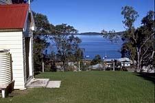
| Myall Lakes with the
porch of the Bungwahl Anglican Church in the
foreground |
There are a variety of ecosystems in the park and hence a
diversity of plant communities and wildlife. Myall Lakes
Park is today a very popular holiday spot and its extensive
waterways are ideal for sailing, surfing, canoeing,
power-boating, kayaking, windsurfing, sunbathing, safe
swimming, camping, waterskiing and bushwalking. There are
river, lake, fishing, deep-sea fishing and dolphin-watch
cruises available, as well as boats and houseboats for hire
at Tea Gardens, Bulahdelah and Nelson Bay. There are canoes,
sailboards, power boats and catamarans for hire at Myall
Shores campground.
There are four main access routes into the park. The
principal road is the Mungo Brush Road via Hawks Nest. The
road is sealed all the way to the ferry. There are also five
signposted beach access tracks for 4WD vehicles which depart
from Mungo Brush Rd (they are only permitted south of The
Big Gibber).
Things to see:
![[Top of page]](smlArrow.gif)
Myall Lakes National Park - Some Walks
Mungo Track
The park starts 4.3 km north of Kingfisher Ave, Hawks Nest.
There is an information board at this point. You can walk
the 21-km Mungo Track to Mungo Brush, a popular camping and
picnic spot on the southern shore of The Broadwater, the
southernmost of the three Myall Lakes where the bird life is
prolific. It starts from a signposted spot 750 m along the
road from the information board.
Dark Point Walk and Wildflower Walk
8 km from the information board is the start of the Dark
Point walk to the right and the Wildflower Walk to the left.
The former leads over a series of impressive sand dunes to a
beautiful and unspoiled coastline looking out over Broughton
Island. Both Broughton Island and the waters off Little
Gibber are noted diving spots. The former is also
well-suited to fishing and bushwalking. However, access is
only provided in the summer season from Nelson Bay and,
sometimes, Tea Gardens. Otherwise you must make your own
way. Little Broughton Island is an important breeding
location for a number of birds. The Wildflower Walk, and the
park in general, are best between August and October.
Mungo Brush Rainforest Walk
The Mungo Brush Rainforest Walk departs from the northern
edge of Mungo Brush campsite and is essentially a loop walk
but it can be as long or short as you like as the paths
branch off to other paths. The first portion of the walk
takes you to the lakeside and then turns off into some dense
and quite beautiful rainforest. You will notice that you are
passing from sand to stone, from paperbark to rainforest,
indicating that you are stepping on to one of the area's
ancient volcanic peaks. Mungo Brush itself is a small rocky
hill that was once an offshore island. There is plenty of
wildlife about the area. Amongst the sedges, broad-leafed
paperbark, swamp oak, coogera and brush bloodwood are
lorikeets, wattle birds, honeyeaters, bowerbirds,
kookaburras, green catbirds, little terns, ground parrots,
the jabiru and tawny frogmouth, eastern grey kangaroos,
echidnae, lace monitors, koalas, sugar gliders, ring-tailed
possums, carpet pythons, flying foxes and bandicoots. There
are also marsupial mice and dingoes in the park. There is a
boat ramp at Mungo Brush and caravan sites are available
from September 15 to October 15 and from December to April.
Other Walks
It is another 2.1 km along Mungo Brush Rd to the White Tree
Bay campsite and another 2.2 km to a parking area on the
right where you can undertake the walks to Johnsons Hill (4
km), Tickerabit (8 km) and Shelly Beach (11 km). Experienced
guides can be hired for all local walks, tel: (02) 4997
0872, or phone the Tea Gardens Visitors' Centre.
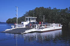
|
| The ferry from Hawks Nest
into the Myall Lakes National Park
|
Bombah Point and the Upper Myall River
It is 20.7 km from the information board at the park
boundary to the ferry at Bombah Point. Every half hour from
8.00 a.m. - 6.00 p.m. it will transport you and your vehicle
the 40 m across to Myall Shores, (formerly Legges Camp) now
a private camping ground, caravan park and convention
centre, tel: (02) 4997 4495. From this point a walking track
leads to the mouth of the Upper Myall River and a very poor
quality unsealed road leads to the township of Bulahdelah,
15 km distant.
Camping in the National Park
There are numerous camping grounds, day-use areas, caravan
parks and picnicking sites. Three of the recognised camping
areas have fresh water: Yagon (3 km south of Seal Rocks),
Mungo Brush (19 km north of Hawks Nest via Mungo Brush Rd)
on the south-eastern shore of The Broadwater where the water
is shallow and you are close to Mungo Beach, and Violet Hill
(9 km from The Lakes Way along Violet Hill Rd) - a
deep-water site where there is a boat ramp, a wharf and a
lookout. Other campgrounds are the shallow waters along the
northern foreshores of The Broadwater from just north of
Mungo Brush around to the ferry, Korsmans Landing on the
western shore of Two Mile Lake (access off Lakes Rd out of
Bulahdelah), and several sites which are only accessible by
boat or foot - the River Mouth (where the upper Myall
empties into The Broadwater), Johnsons Beach on the southern
shore of Boolambyte Lake, Tickerabit and Shelly Beach, both
on the southern shore of Myall Lake. There are fees but
bookings are not essential.
Myall Shores (formerly Legges Camp) at Bombah Point (at
the end of Lakes Rd) is now a private camping ground,
caravan park and convention centre, tel: (02) 4997 4495.
There is a ferry service from here across to Mungo Brush
from 8-6 daily. There is also a day-use area just north of
Mungo Brush on the eastern side of the road with toilets and
barbecues.
There are boat-launching ramps at Bombah Pt, Mungo Brush,
Violet Hill and Bungwahl, a township at the northern end of
Myall Lake (access via The Lakes Way). There are also ramps
at Nerong, Bulahdelah and Hawks Nest-Tea Gardens.
Accommodation and Eating
For all Accommodation and Eating connected to Myall Lakes
refer to the specific information provided in the entries on
Bulahdelah,
Hawks Nest, and
Tea Gardens.

Broadwalk
Business Brokers
Broadwalk Business
Brokers specialise in General Businesses for Sale, Caravan Parks for
Sale, Motels for Sale, Management Rights & Resorts for Sale, Farms for
Sale, Hotels for sale,Commercial & Industrial Properties for Sale.
Phone:
1300 136 559
Email:
enquiries@broadwalkbusinessbrokers.com.au
AUSTRALIAN BUSINESSES FOR SALE
COFFS HARBOUR BUSINESS BROKERS
BROADWALK BUSINESS BROKERS
GOLD COAST BUSINESSES FOR SALE
BRISBANE BUSINESSES FOR SALE
SYDNEY BUSINESSES FOR SALE
CARAVAN PARKS FOR SALE
BUSINESSES FOR SALE
MOTELS
FOR SALE
HOTELS
FOR SALE
Disclaimer
We advise prospective purchasers that we take no
responsibility for the accuracy of any information in the business
provided by vendors or their professional advisers and that they should
make their own enquiries as to the accuracy of this information,
including obtaining independent legal and/or accounting advice
Myall Lakes