|
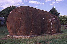
| The Big Potato
|
Robertson
Small township near the edge of the Southern Highlands
noted for its rich soils and undulating landscape. Famous as
the setting for the movie Babe
Located 128 kilometres from Sydney and some 730 metres above
sea-level (although the coastal towns of Shellharbour and
Kiama are only a half an hour away) Robertson is a small,
quiet village on the Illawarra Highway just west of the
Illawarra escarpment and Macquarie Pass which functions as a
link between the South Coast and the Highlands. Consequently
there are spectacular views across the coastal plain to the
Pacific Ocean from some of the town's vantage points.
The town is noted for its distinctive red volcanic basalt
soil which is known as Robertson soil. The combination of
this soil, a good rainfall and cool winters has made the
town the centre of the largest potato-growing area in NSW.
In fact, as is the wont with Australian country towns, the
main street boasts a large brown, cylindrical object which,
although not marked, one assumes is ŒThe Big Potato¹.
The town is also the centre of a dairy industry with an
old dairy factory at the eastern end of the town. It was
also the setting for the very European-English countryside
of the Australian movie Babe.
|
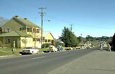
| The main street of
Robertson |
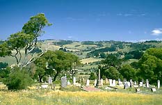
If you turn south on Meryla Street and drive out to the
cemetery you get an excellent view over the dairy lands of
the area which have a distinctively English feel about them.
Charles Throsby passing south from the Moss Vale area to
Kangaroo Valley in 1818, en route to Jervis Bay, sent his
servant Joseph Wild off with some local Aborigines to have a
look at the area east of Moss Vale which became known as the
Yarrawa Brush. With the help of local Aborigines Throsby
later found a route up from the Illawarra.
Surveyor Robert Hoddle and a gang of convicts cut a
bridle path down the slopes in 1830 as part of a track
intended to join the Cowpastures (Camden) to Kiama and
Gerringong. He described the Yarrawa Brush as 'the most
formidable brush I have ever seen. The vines so thickly
entwined around the huge trees and small as to render the
sun obscure at the time it shone with great brilliancy'.
It was the town's rich soil which fostered the dense
rainforest which once covered the entire plateau and which
kept the settlers away for so long after it was discovered.
But, in the end, they destroyed nearly all of it to
establish their homes and farms.
It was the 1861 Land Act of Sir John Robertson (former
Premier of NSW) which cleared the way for the establishment
of the town which took his name. It provided for free
selection before survey of unreserved blocks of crown land
at £1 per acre with a 25 per cent down payment and the rest
to be paid at leisure provided the owner lived on the land
for three years and made certain improvements to it.
In 1862 Kiama alderman John Hanrahan and his
brother-in-law William Davis investigated the Yarrawah
Brush, found and followed Hoddle's track, located some
excellent land and selected it. This was reported in the
Kiama Independent newspaper, encouraging others from
Jamberoo and Kiama to follow. Land was reserved by the
government that year as 'Three Creeks'.
A basic track from Kiama was cut in 1862, another from
Albion Park in 1863, and the new settlement was joined to
the Old South Road via Kangaloon in 1867. The townsite was
surveyed in 1863 by Surveyor Campbell who was so impressed
he reserved land for himself and built 'Rossgol' which is
still standing. He drew up a town plan which was approved in
1865. By that time there were 1200 selectors who had taken
up 30 000 acres of land, despite the fact that it was a
three-day ride for supplies and 30 km to the nearest doctor.
The first lots were sold in 1865 and the village was, at
first, called 'Yarrawa'. The first school in the village was
built in 1872 and what was probably the first store in 1876.
A slab building for methodists went up c.1870, to be
replaced by a church proper in 1888. The Anglican church
opened in 1876.
|
| The view across the
rolling hills from the cemetery |
Steam-driven sawmills opened up in the district in the
1870s creating a demand for local timber. Shops and houses
began to appear in the early 1880s. A post office appeared
in 1884 and a school of arts in 1886. By the following year
the town had two hotels, two bank branches, three stores, a
baker, a bootmaker, a chemist and five butchers. A police
station was built in 1887. After the depression of the 1890s
growth ceased until the 1920s.
The Burrawang Farmers Club was established in 1878 to
promote the improvement of roads, facilities and farming
techniques. This organisation evolved into the Robertson
Agricultural and Horticultural Society and fostered the
first Agricultural Show which was held at Burrawang in 1880
and was transferred to Robertson in 1886.
Macquarie Pass was opened in 1898 facilitating commerce
and connections with the coast and with Sydney as the
Southern Highlands railway had not extended to Robertson. A
motor service carrying passengers and goods commenced
operations in 1912. The railway did not arrive until 1932
despite agitation which commenced in 1872.
Today Robertson is a pleasant, small and quite uneventful
rural town which makes for an enjoyable stopover.
Things to see:
Tourist Attractions in the Town
In recent years a minor tourist industry has emerged based
on a number of antique, bric-a-brac and pottery shops in
Hoddle St (the name of the Illawarra Highway as it passes
through town). Old Time Music Machines, at Lot 1, is a music
memorabilia museum offering morning and afternoon teas and
panoramic views. It is open from 10.00 a.m. - 4.00 p.m. from
Wednesday to Monday, contact (02) 4885 1133. The Village
Woodworks are at Lot 14. There is a wooden toy factory with
arts and crafts and gifts at The Old Cheese Factory, contact
(02) 4885 1133. The are closed on Tuesdays. Robertson
Pottery is opposite the County Inn, and is open Friday to
Monday and public holidays from 10.00 a.m. - 5.00 p.m. ,
contact (02) 4885 1371, and Robertson Recollections at 26
Hoddle St has old wares, interesting books, curios and
antiques. It is open Friday to Tuesday 9.30 a.m. - 5.30
p.m., (02) 4885 1080.
Ranelagh House
The town's most distinctive and gracious building is
Ranelagh House, a guest house and conference centre to the
east of the town. Built in 1924 as the Hotel Robertson it
was conceived as an imitation English Manor House and is set
in 13.5 acres of landscaped gardens, complete with statues,
swimming pool, fountains and a weir. There are deer and
peacocks on the grounds. There is also a craft cottage on
the grounds.
The original owners must have hoped that they could draw
some of the Sydneysiders who retreated to the cool Southern
Highlands to escape the heat of a Sydney summer and enjoy
the beauty of the countryside. However, it was not really a
success and the enterprise folded. In 1930 it was purchased,
marketed as an exclusive country club and renamed Ranelagh
House. However, it again failed to make headway. During
World War II it was used as a WRAAF depot before becoming,
in 1947, St Anthony's College, a Franciscan friary and
seminary. It was during this period that the stained-glass
windows were incorporated. The house once again became a
private hotel in 1972 and is at last fulfilling its intended
purpose as a retreat from Sydney.
Ranelagh House has its own platform on the Moss Vale to
Unanderra line and hence is easily accessed by means of the
Cockatoo Run which offers an opportunity to see the
surrounding countryside by means of a leisurely train trip
in olden-style carriages (pulled by steam train except in
exceptional circumstances) to Robertson or down to the
lllawarra. It operates from Saturday to Tuesdays and on
public holidays, contact (1800) 64 3801.
Bushwalking in the area
The surrounding countryside is ideal for bushwalking. There
is an exceptional 5-hectare remnant of temperate rainforest
south-east of town at Robertson Nature Reserve which
provides a good idea of how the whole plateau once looked.
To get there turn south off the Illawarra Highway, just past
the County Inn at Robertson, cross the railway line, turn
left again at the T-intersection into South St and proceed
about 100 m to the car park on the right. There is a 600-m
circular walking track around the reserve with interpretive
signage and disabled access.
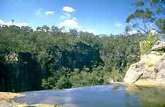
|
| The top of Belmore Falls
|
Belmore Falls
If you return in a westerly direction along South St, past
the intersection with Meryla St, you will soon come to a
left turn into Belmore Falls Rd. It is about ten minutes
along a partially tarred road to another left turn
(signposted for Hindmarsh Lookout) which will take you to
the small parking area. It is a short walk to Hindmarsh
Lookout from where there are truly breathtaking views over
Morton National Park and Kangaroo Valley. From Hindmarsh
Lookout there is another trail which follows the cliffline
for about 300 metres to an equally impressive lookout over
Belmore Falls. They were named after the then-governor of
NSW, the Earl of Belmore. This isolated and undeveloped site
has been a drawcard since a road was established in 1887,
although there are rarely many people about at any one time.
The Fitzroy Falls Visitors' Centre has a pamphlet on the
history of the area and the lookouts. The water that drops
dramatically for over 100 metres from two of the falls into
the Barrengarry Creek Valley joins the Kangaroo Creek and
becomes part of the upper reaches of the Shoalhaven River
catchment area. This is an ideal place for a bush picnic.
The facilities are basic but the peacefulness of the picnic
spots beside the river make this a cool and quiet respite
from the bustle of the city. From the parking area just
follow the road which loops back to rejoin Belmore Falls
Road. Turn right to return to Robertson or left if you wish
to continue on to Fitzroy Falls.
Fitzroy Falls
From the Belmore Falls parking area just follow the road
which loops back to rejoin Belmore Falls Road. Turn left and
it is 5.3 km to a T-intersection. A right turn into Myra
Vale Rd will take you back to the Illawarra Highway just
west of Robertson. A left will take you towards Fitzroy
Falls. After a further 7.5 km there is a T-intersection. A
left will take you to Kangaroo Valley township and on to
Nowra. Turn right,driving past the Fitzroy Falls Reservoir
and picnic area, where there is achildren's playground. A
short distance further along is the turnoff to the Fitzroy
Falls Visitors' Centre (see entries on Fitzroy Falls,
Bundanoon and Milton-Ulladulla for further information on
the park). It is 5 km to the T-intersection. A right turn
into Myra Vale Rd will take you back to the Illawarra
Highway just west of Robertson. A left will take you towards
Fitzroy Falls. After 7.5 km there is a T-intersection. A
left will take you to Kangaroo Valley township and on to
Nowra. Turn right, driving past the Fitzroy Falls Reservoir,
to the Fitzroy Falls Visitors' Centre (see entry on
Fitzroy Falls).
Macquarie Pass National Park
Alternatively, if you head east of Robertson along the
Illawarra Highway to Macquarie Pass, which leads
precipitously down a section of the Illawarra escarpment to
Albion Park, you will pass through the beautiful rainforest
scenery of Macquarie Pass National Park. There are three
walks. The Glenview Track, which departs from Glenview Rd (a
left-turn off the middle section of the pass when you are
descending), the Clover Hill Rd Walk (an old logging trail
halfway down and to the right if you're descending) which
leads to several falls (6 km return and only for the
experienced walker armed with a compass) and, the easiest of
all, the Cascades Rainforest Walk (2 km return) which begins
from the car park on the northern side of the highway at the
foot of the pass. The park contains lyrebirds, satin
bowerbirds, crimson rosellas, wallabies, wombats and
bandicoots. There are several picnic spots.
Carrington Falls
If you turn off the Illawarra Highway, just east of
Robertson where the highway bends to the left, and turn
right into the Jamberoo Rd, then, after 10 km, you will come
to a signposted turnoff to the right which takes you to
Nellies Glen Picnic Area and Carrington Falls. After 2 km
this branch road forks. The road on the right leads to
Nellies Glen and that on the left to Thomas' Place Picnic
Area. A track (2 km return with disabled access) departs the
latter and leads to three lookouts over the beautiful falls
which tumble 50 metres over the Kangaroo Valley escarpment.
Barren Grounds Nature Reserve
Barren Grounds Nature Reserve, Gerringong Falls, Jamberoo
Lookout and Minnamurra Rainforest all lie further along the
Jamberoo Rd and are all outstanding spots for walking and
enjoying the beautiful scenery (see entry on Jamberoo).
Another alternative is the Kangaloon Rd to Bowral which
involves a turnoff to the right in the middle of Robertson
(if you are headed from east to west along the highway).
About halfway along the 24-km stretch of road is the
Wingecaribee Reservoir where there is a picnic area. En
route is some beautiful scenery and the villages of East
Kangaloon and Kangaloon, established around the same time as
Robertson by the same batch of settlers.
Robertson Agricultural Show
The Robertson Agricultural Show is held in March. The
Robertson markets are held on the second Sunday of each
month at the old Robertson school of arts building in Hoddle
St.

Broadwalk
Business Brokers
Broadwalk Business
Brokers specialise in General Businesses for Sale, Caravan Parks for
Sale, Motels for Sale, Management Rights & Resorts for Sale, Farms for
Sale, Hotels for sale,Commercial & Industrial Properties for Sale.
Phone:
1300 136 559
Email:
enquiries@broadwalkbusinessbrokers.com.au
AUSTRALIAN BUSINESSES FOR SALE
COFFS HARBOUR BUSINESS BROKERS
BROADWALK BUSINESS BROKERS
GOLD COAST BUSINESSES FOR SALE
BRISBANE BUSINESSES FOR SALE
SYDNEY BUSINESSES FOR SALE
CARAVAN PARKS FOR SALE
BUSINESSES FOR SALE
MOTELS
FOR SALE
HOTELS
FOR SALE
Disclaimer
We advise prospective purchasers that we take no
responsibility for the accuracy of any information in the business
provided by vendors or their professional advisers and that they should
make their own enquiries as to the accuracy of this information,
including obtaining independent legal and/or accounting advice
Robertson