|
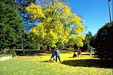
| Autumn in Central Park
|
Armidale (including Mt Yarrowyck, Oxley Wild Rivers
National Park, New England National Park, Styx River State
Forest and Cathedral Rock National Park)
Major city in the New England area
Armidale is located 525 km north-north-west of Sydney and
465 km south-west of Brisbane within the district known as
New England. An attractive and graceful city of tree-lined
streets where new world cosmopolitan and old world
pastoralism coexist with varying degrees of harmony, it is
the major centre of the Northern Tablelands with a
population of over 25 000. Situated a cool 980 m above
sea-level Armidale has the highest airport in Australia.
The city, unlike most of Australia, has four distinct
seasons. The justness of naming the district New England is
particularly apt when the introduced birch, ash and poplar,
which lend such a European feel to the city, set the town
ablaze with reds, golds and browns in autumn.
Grazing and the production of high-grade fine wool are
the major source of local income although dairying, timber
processing and the production of potatoes and stone fruits
are also important. There are many well-established and
wealthy grazing families in the area. The money of the
district is apparent in some of the city's fine heritage
buildings.
There is plenty of impressive scenery around Armidale,
including forests, mountain gorges, waterfalls (Wollomombi
Falls are one of the highest in Australia) and four national
parks.
Armidale also has plenty of parkland and a strong
reputation as a major educational and ecclesiastical centre.
The University of New England was the first public
university to be established outside of the capital cities.
The town also boasts two major cathedrals facing Armidale
Central Park, and St Nicholas's which is registered on the
National Estate.
The collection at the New England Regional Art Gallery is
considered by many as the best of any country gallery in
Australia, with a particularly impressive array of
Australian paintings from the late 19th and early 20th
centuries.
|
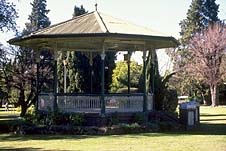
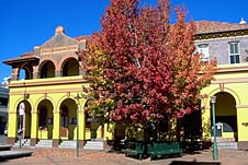
| The band rotunda in
Central Park |
The Armidale Autumn Festival runs throughout the autumn
(March to May), incorporating numerous events, including the
Armidale Show in early March. The Wool Vision Showcase, held
in early May, is a showcase for the district's wool industry
and the Saumarez Homestead Fair takes place in early May.
The markets are held on the last Sunday of each month in the
Beardy St mall with a livestock, double header auction held
on the 3rd weekend of each month.
For thousands of years before white settlement the New
England area was occupied by Aboriginal groups who used it
as a meeting place on trading routes between the coast and
inland areas. The Anaiwan and Kamilaroi seem to have been
predominant in the area.
Explorer John Oxley passed through the New England Area
in 1817-18. White settlement commenced with squatters who
began opening up the country around 1832. The Saumarez and
Tilbuster stations were taken up around the present-day site
of Armidale by Henry and William Dumaresq in 1835. Henry,
the brother-in-law of Governor Darling, was a member of the
Duke of Wellington's staff in the Battle of Waterloo in the
course of which he was shot through the lungs while
delivering a message. Consequently he suffered ill health
for the rest of his life and died young in 1838. His brother
William was a veteran of the Peninsular Wars and the
son-in-law of the colonial secretary.
In 1839, a part-time poet with close Aboriginal
associations, G.J. Macdonald, acting as the commissioner of
crown lands, made part of Tilbuster station his
headquarters. He described the site, now occupied by
Macdonald Park in East Armidale, as 'an extensive, open
plain, well watered and sheltered and centrally situated'.
Macdonald named the area after his clan's baronial estate of
'Armadale' on the Isle of Skye.
A slab and bark village grew in 1839 as a government
administrative centre around Macdonald's office, store and
barracks. The first post office opened in 1841 and the first
church service was held in 1845. Applications were made for
land in 1845-46. Though wool-cultivation was the main
economic activity a steam-powered flour mill was built in
1846. The first school (Anglican) was established the
following year.
A townsite was surveyed in 1848 and gazetted in 1849. The
town benefited from being situated on the Great Northern
Road with Cobb and Co establishing a service in 1850 . The
following year the population was recorded at 547. An early
description of the village depicted it as 'a large piece of
naturally clear land, looking precisely like an English race
course framed in gum trees'. There was local conflict with
the indigenous peoples in the early days though few details
appear to have survived.
The discovery of gold at Rocky River, near
Uralla, in 1852 was the first of numerous such finds in
the district. This brought new money to the town which
caused a spurt of growth. The Armidale Express newspaper
commenced operation in 1856 and, in 1861, a public school
and school of arts were established.
The railway arrived in 1883 and Armidale was proclaimed a
city in 1885 with a population well in excess of 2000. In
the last 20 years of the century Armidale established itself
as an educational centre with the opening of St Ursula's
(1881), the Ladies' College (1889), the grammar school, the
Armidale School (1894) and New England School (1895).
The years after World War II saw a considerable growth in
the town's population, thanks in large part to the expansion
of tertiary education. There are something like 17 000
tertiary students enrolled at Armidale out of a total town
population of some 22 000.
Things to see:
![[Top of page]](smlArrow.gif)
Visitors' Information
The Armidale Visitor Information Centre is located in Curtis
Park, on the corner of Dumaresq and Marsh Sts. There is
information on self-drive scenic and heritage tours of the
district, heritage walks of Armidale and Hillgrove,
horseriding in the area, fishing in a district noted for its
trout, guided trout fishing tours, gem fossicking, farm
holidays, sightseeing, abseiling, rafting, swimming and
picnic spots, tel: (02) 6772 4655 or (free-call) 1800 627
736. The email address is armvisit@bigpond.net.au
Heritage Walk
Central Park
A logical place to start a walking tour of Armidale is in
Central Park which is the centre of the city. Bounded by
Faulkner, Barney and Dangar Sts and Tingcombe Lane it is an
attractive, dignified reserve which was dedicated in 1874 as
a recreational area. The band rotunda was built as a 1902
Boer War Memorial. There is also a tourist directory, a
memorial fountain dedicated to those from the district who
served in World War I, and picnic and toilet facilities. The
well-established trees are quite beautiful, particularly in
autumn.
|
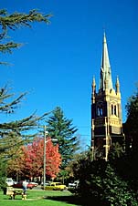
| St Mary's and St Joseph's
Catholic Cathedral |
Catholic Cathedral
The two most obvious landmarks about the park are the two
cathedrals. St Mary's and St Joseph's Catholic Cathedral on
the other side of Dangar St is the town's dominant building.
A Gothic Revival structure of Pyrmont stone and polychrome
brickwork it was built in 1911-12 to replace an earlier
church (1870-72) which, in turn, replaced the first wooden
chapel on the eastern side of the city (1848). Features
include the lantern tower with its turrets and needle spire,
the hammerbeam roof, the cylindrical stone columns within
and the marble work of the altar and chancel.
St Peter's and Merici House
Nearby, on the corner of Dangar and Rusden Sts, is the
splendid High Victorian Gothic design of St Peter's Anglican
Cathedral, the work of J. Horbury Hunt, arguably Australia's
most distinguished colonial architect. Considered one of
Australia's most interesting and innovative ecclesiastical
designs it was built between 1871 and 1878 to replace an
earlier 1850 church. The chapter house and vestry were added
in 1910 and the tower 1936-38.
The brickwork is outstanding featuring the usage of many
types of moulded brick. Details include square towers and
buttress finials capped by pyramids (a Hunt motif), Gothic
arches, gables, a sandstone pulpit, a brass lectern, piers
and stained-glass windows which are individual tributes to
early settlers. It is a work of consummate craftsmanship and
complexity.
The village's first resident clergyman was the Reverend
Henry Tingcombe, after whom the laneway was named.There is a
museum in the bell tower with items relating to parish and
diocesan history which is open from 9.00 a.m. - 4.00 p.m.
weekdays. Admission is free.
On the other side of Dangar St is Merici House which was
built as St Mary's School in 1862. Angela Merici was the
founder of the Ursuline Order of nuns who began teaching at
the school in 1883.
Jessie St
Head west along Rusden St to the corner with Jessie St which
was named after the ship which brought Henry Dangar to
Australia in 1821. On the north-eastern corner is 'Minto',
built in 1894 as the Central Hotel, although the design has
been greatly altered over the years. On the north-western
corner is the city's second Baptist Church, built in 1918 to
a Gothic Revival design. If you head south down Jessie St
halfway along the block is the Ursuline Convent, built in
the 1860s and extended 1901-02.
Beardy St
Return north along Jessie St, turning right into Beardy St,
named after Chandler and Duval, two hirsute stockmen who
acted as guides for squatters in the earliest days. On the
right, at no. 208, is the State Bank, built 1887-89 as the
Australian Joint Stock Bank. It has a decorative facade and
columns at the entrance to the banking chamber which has an
elegant cedar interior with carved counters, marble
mantelpieces, festoons and panelling on the walls and
ceiling. The residence is fronted by a wrought-iron gate.
Outside the National Bank is Armidale's only remaining
hitching post. Over the road is Richardson's Store located
in the old Capitol Cinema (1925). Richardson's was
previously located on the north-western corner of Dangar and
Beardy Sts. The building at that corner bears the date
'1842' on the facade. This refers to the year of the firm's
establishment in Queensland and perhaps also to the first
store built on this site. Richardson's built their first
store here in 1872 and had the present building erected in
1903.
Diagonally opposite is the New England Hotel, established
on this site in 1857. The current building dates from 1897.
The Stables
Slightly north along Dangar St, at the corner with Moore St,
is an 1872 cottage known as The Stables, situated behind the
National Bank building. There is a hoist over the main door
to service the loft. It is currently open as a gift shop.
Sheriff's Cottage and Courthouse
Walk down Moore St to Faulkner St. On that corner is the
Sheriff's Cottage, a simple, vernacular single-storey brick
magistrate's residence with timber verandah. Built in 1870
it was originally the town lock-up.
The cottage lies behind the simple brick courthouse
(1859-60) on the north-western corner of Beardy and Faulkner
Sts. It replaced an earlier building erected on a different
site in 1844. Designed by Alexander Dawson, later
alterations were made by James Barnet in 1870 and W.L.
Vernon in 1900. It features a grand portico with half-fluted
entrance columns, a vented pediment, cedar joinery and
furniture and a squat clock tower, added in 1878. Other
features include a cobbled vestibule and fine wrought-iron
gates.
In 1971 a message was found in a cognac bottle placed
under the floorboards during the renovations which had
occurred in 1870. Written by the Clerk of Petty Sessions it
read, in part: 'My friends...rest assured that the world has
wagged before your time as it will after your time, and that
nothing is certain but death. For and behalf of my numerous
creditors. Sydney Blythe.'
AMP and Bank of NSW Buildings
On the north-eastern corner is the Westpac Bank, built as
the Bank of NSW c.1938, with a detailed facade, metal-framed
windows and heavily panelled timber doors.
Next door, in Beardy St, is another attractive
20th-century building, the AMP Building (1929) with a
Georgian Revival stuccoed brick facade, sandstone entrance,
multipaned windows with timber frames and shutters, a
mansard roof with terracotta tiles and sculpted figurines
above the parapet.
|
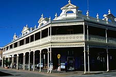
| Imperial Hotel (1889)
|
Imperial Hotel
On the south-eastern corner of Beardy and Faulkner Sts is
the two-storey brick and stucco Imperial Hotel (1889).
Armidale's oldest surviving hotel this highly ornamented
building features extensive cast-iron friezework on the
verandahs, bull nosed awnings, and extravagant parapets
decorated with Grecian urns and pediments on arches. The
interior retains an air of Victorian opulence.
Post Office and Lands Board Office
On the south-western corner is the two-storey Classical
brick and stucco post office (1880) designed by James Barnet
with a balcony and colonnade added in 1897 by W.L. Vernon.
|
| The Armidale Post Office
|
Next door, at 164-66 Beardy St, in the mall, is the Lands
Board Office (c.1882), now a series of shops. It is a
two-storey Classical Revival brick and stucco building
designed by James Barnet with chimney pots and original
slate roof. It later became the telegraph office, at which
time the single-storey front section with arched doorways
and windows was added. From 1932 it functioned as the CBA
Bank.
Lands Department Office
Return to Faulkner St. Next door to the post office, at no.
108, is the Lands Department Office (1886), a two-storey
High Victorian public building designed by James Barnet with
walls of English bonded brick. It features an elegant and
elaborate belled iron verandah and balcony with cast-iron
columns and balustrades.
Folk Museum and Town Hall
Further south on Faulkner St, on the corner with Rusden St,
is the old School of Arts and Mechanics/Literary Institute.
The original corner section was built in 1863 with an
office, library and billiards room added in 1897. It is made
of stuccoed brick with a fine cast-iron verandah and a
central parapet with a gun motif bearing the name of the
Literary Institute. It is now a folk museum with local
artefacts, open seven days from 1.00 p.m. - 4.00 p.m.
Admission is free and group tours can be arranged in
advance, tel: (02) 6770 3536.
Next door (along Rusden St) is the two-storey High
Victorian town hall (1882-83). The decorative stuccoed brick
facade includes pilasters, scrolls, frieze work and a
central pediment.
Wesleyan Church
East along Rusden St is the Wesley Uniting Church and Hall.
The present hall was the town's first Wesleyan Church
(1864). The present church dates from 1893. The pipe organ
was made in 1879. Note the circular window above the front
gable flanked by two Gothic stained-glass windows.
St Paul's Presbyterian Church
Further south on Faulkner St, to the right, opposite
Tingcombe Lane, is St Paul's Presbyterian Church (1881-82),
a Gothic revival design with a tall steeple, wrought-iron
ornamentation, arched lancet windows and rose window.
Faulkner St
Adjacent the church, at 139 Faulkner St, is Solomons'
Cottage, built of English bonded brick in 1872 for Henry
Solomons who established a photographic studio in 1880.
Still in the family it is a Georgian design with a bullnose
verandah.
Next door, at the Barney St corner, is NSW's first
Masonic temple which has a fine leadlight gallery.
Diagonally opposite, at 128 Faulkner St, is Lindsay House
(1880s).
S.H. Smith House
West along Barney St, at the corner with Dangar St, is S.H.
Smith House, built in 1889 of Flemish brickwork. It
originally served as New England Ladies' College which
closed in 1904. In 1928 it became part of Armidale Teachers'
College and was substantially altered. In 1960 it was joined
with 'Southhall', a two-storey building dating from 1886
with chimney pots, cast-iron lacework verandahs and cedar
doors, staircase and mantelpieces.
Dangar St
Turn left into Dangar St. To the left, at no. 133, is Arran
Cottage (1863), built in 1863 for one of Armidale's first
doctors. With the aid of the Anglican church his wife ran a
Ladies College there from 1875. The house behind it, at 133
Dangar St, was built in 1862.
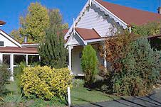
Residential and Heritage Walk
The following can be considered either as a separate walk or
an extension of the preceding walk. It takes off precisely
where the last walk concluded and takes in some of the
town's residential heritage, as well as two historic
educational centres, the town's impressive art gallery and
the Aboriginal Cultural Centre.
Head south along Dangar St, across Brown St and, to the
left, is Armidale City Public School which opened on private
premises in 1861. It shifted to the present site in 1865.
Before that time this was the town's first cemetery (from
1846 to 1859) and police barracks. Opposite the school, at
160 Dangar St, is the former Hilton School (c. late 1880s).
The house at 176 Dangar St was built c.1900.
Turn right into Mann St. At no. 146 is Linden Hall, built
of Flemish bonded bricks c.1880 with later additions. The
building has a bullnose verandah and decorative bargeboards
on the front gable.
Turn left into Jessie St then left again into Mossman St.
At no. 145 is 'The Turrets', built in the 1860s for a member
of the Richardson family. The house's name derives from the
turretted bay windows. There is an interesting old buggy
shed on the grounds.
C.B. Newling Building
Turn right into Dangar St then left at Kentucky St. To the
left is the old Armidale College of Advanced Education, the
Old Teachers College, and now known as the C.B. Newling
Building. From 1863 to 1920 this was the site of the town
gaol where six hangings were executed. It also doubled as an
insane asylum. The college purchased the site in 1927 and
the current building opened in 1930, the first teacher's
college in NSW outside of Sydney. Situated atop a hill
amidst formal gardens it is a Classical design featuring six
Ionic columns, stained-glass windows, round-headed windows
and an impressive art collection.
The college's Educational Museum sits opposite, to the
right of Kentucky St. It consists essentially of three
19th-century school buildings featuring teaching devices and
furniture from the mid-Victorian era. One of the buildings
is the re-erected Standard School of Pallamallawa. It is
only open by prior arrangement and only to large groups.
There is a small entry fee, tel: (02) 6773 6466.
At the corner of Dangar and Kentucky Sts is the college's
Heritage Centre which maintains the town's and university's
historical archives. It is open to the public on weekdays
from 9.00 a.m. - 5.00 p.m., tel: (02) 6773 6466.
New England Regional Art Museum
A little further along Kentucky St, at the corner with Marsh
St, is the New England Regional Art Gallery. Its collection
is considered by many as the best of any country gallery in
Australia, with a particularly impressive collection of
Australian paintings from the late 19th and early 20th
centuries, including Tom Roberts, Norman Lindsay and Arthur
Streeton. There are also pieces by Kandinsky and Rodin.
Situated in Kentucky St it is open Tuesday to Sunday from
10.30 a.m. to 5.00 p.m., tel: (02) 6772 5255.
Aboriginal Cultural Centre and Keeping Place
Adjacent the gallery is the Aboriginal Cultural Centre and
Keeping Place with visual and performing arts programs
designed to preserve and inform about Aboriginal and Torres
Strait Island art and culture. There are also arts and
crafts from the indigenous communities for sale, open
weekdays from 10.00 a.m. to 4.00 p.m. and weekends by
appointment, tel: (02) 6771 1249.
Residential Walk - Final Section
Turn into Marsh St, left along College Avenue, and right
into Faulkner St. Just over Mossman St, at 160 Faulkner, is
'Uloola' (1908). This property originally occupied the
entire block bounded by Faulkner, Mossman, Dangar and
Reginald Sts.
Turn right into Mann St. At no. 118 is 'Loombra' (late
1880s). Used in the 1950s as a residence for the College of
Advanced Education it has some fine cast-iron ornamentation
and large bay windows. At no. 108 is 'Teringa' (c.1889), a
two-storey building with an impressive, detailed facade.
Turn left into Marsh St. To the immediate right, at 179
Marsh St, is an attractive Georgian cottage of Flemish
bonded brick.
Head north along Marsh St to Brown St. On the
south-western corner is 'Birida' (1907), an impressive
Federation house of a complex design with towers, bay
windows and ornamental gables. Opposite, at 168 Marsh St, is
Belmore Cottage (1866).
Turn left into Brown St and right into Faulkner. To the
left, at no. 132 is Denham Cottage Lodge with its numerous
gables. Its construction has been variously given as the
1890s and 1913. Central Park is just down the road.
Armidale Bicentennial Arboretum
Armidale Bicentennial Arboretum is bounded by Kentucky,
Butler and Galloway Sts. It contains thousands of native and
imported shrubs and trees, walking tracks, a north-facing
lookout, picnic shelters, a toilet block and aquatic gardens
with a waterfall and walkbridge. There is also a senses
garden near the entrance.
Railway Complex
In Brown St are the railway station and station master's
residence. The Bicentennial Railway Museum adjacent the
station has railway equipment, vehicles and other related
items. There is also a collection of police memorabilia.
Viewings of the interior are possible between 11.00 a.m. and
11.30 a.m. daily. Admission is free, tel: (02) 6770 3536.
Cycleway
A 4.7-km bicycle track leads from from the city to the
University of New England. It starts from Harris Park
(Dumaresq St) and bikes can be hired from Armidale Bicycle
Centre at 248 Beardy St, tel: (02) 6772 3718, or from the
University's Sports Union, tel: (02) 6773 2316.
University of New England
The University, situated at the town's north-western corner,
off Queen Elizabeth Drive, occupies some 260 ha, including
some very pleasant stretches of lawn and parkland. The
administration building is the superb 'Booloominbah', a
grandiose, three-storey, 45-room red-brick country mansion.
It is a typically complex and asymmetrical design by J.
Horbury Hunt, built between 1883 and 1888 for the White
family, whose most famous member is the Nobel Prize-winning
novelist Patrick White.
The building features truncated pyramid chimneys, shady
balconies and verandahs, a square tower, projecting wings
and gables, arched doorways, massive chimneys, large
stained-glass windows depicting scenes from the life of
General Gordon, dark oak panelling, a large cedar staircase
and an extensive art collection.
There is an 8-ha deer park to the rear. The fallow deer
were imported from Indonesia by Frederick White in the
1890s. There are also wallabies and kangaroos.
Frederick White died in 1903 and his wife stayed on in
the house until her death in 1933. In 1938 her son-in-law
donated it so that it may constitute the basis of the New
England University College of Sydney University, the first
university outside of the capital cities. In 1954 it became
an autonomous institution and 'Booloominbah' became the
administrative centre. It is at the end of Booloominbah
Drive, which extends off Elm Ave.
'Trevanna', also designed by Hunt, was built in 1889 for
Phillip Wentworth Wright as a summer residence for his wife
and daughters. Erected on stone foundations it has rubble
walls, a hipped and gabled slate roof and brick surrounds.
'Trevanna' now serves as the vice chancellor's residence.
The Museum of Antiquities, in the Arts building (in Arts
Rd), features archaeological finds from Greece and Rome as
well as parts of Europe and the Middle East and some
Australian Aboriginal material. It is open from 9.00 a.m. -
4.30 p.m. weekdays with free admission. Group bookings can
be made by appointment, tel: (02) 6773 2555.
The Zoology Museum, adjacent Trevenna Rd, has a wide
range of zoological specimens from Australia and throughout
the world. It is open weekdays from 9.00 a.m. to 5.00 p.m.
weekdays, tel: (02) 6773 2865. Admission is free.
Drummond Park
Drummond Park, at the corner of Jessie and Donnelly Sts,
features the Apex Memorial Lookout, which offers views over
the city.
|
| The Old Homestead at
Moore Park Inn |
Scenic City Walks
Another way to see the park is to follow the 2.8-km loop
walk which starts and finishes at the trackhead sign
adjacent Stephens Bridge on Marsh St. It follows Dumaresq
Creek for a distance then heads north to Drummond Park.
It is also possible to walk from the aforesaid trackhead
north-east to the 'Pine Forest' (Armidale State Forest).
Follow Dumaresq Creek in the opposite direction then head
north along Box Hill Drive to Rockvale Rd which leads to the
Pine Forest on the banks of Commissioners Waters. Depending
on the route you choose this is a distance of some 6 to 9
km.
The Pine Forest is a very popular spot which can also be
easily reached by car. There are toilets, tables, barbecues,
water and wood. Another walk starts at the trackhead sign by
the seating area and follows a path marked with posts
through the forest to the Rockvale Rd, along Trelawney Rd to
another part of Commissioners Waters. It then pursues the
waterway through Charleston Willows Reserve back to the Pine
Forest. A longer route is also available. There is a
pamphlet outlining all of these walks from the visitors'
centre.
In the background, north-west of town, is Mt Duval, named
after John Duval, a ticket-of-leave convict in charge of
cattle on William Dumaresq's original Tilbuster station.
Armidale School and Macdonald Park
The Armidale School, at the corner of Barney and Douglas Sts
in East Armidale, opened in 1894 under the control of the
Anglican church. Impressive architecturally it consists
mostly of two-storey polychrome brick buildings with
interesting roof forms. The gables feature terracotta
plaques, copings and finials. The whole is set in park-like
grounds. The chapel, designed by Cyril Blacket and built in
1902, blends well with the other buildings. The interior is
attractive and features an impressive pointed brick arch
over the altar.
Adjacent is Macdonald Park, originally known as
Commissioner's Paddock as it was on this site, in 1839, that
part-time poet G.J. Macdonald, acting as the commissioner of
crown lands, established his headquarters and hence
precipitated the emergence of Armidale. He described the
site as 'an extensive, open plain, well watered and
sheltered and centrally situated'. There are picnic,
barbecue and childrens' play facilities.
Dumaresq Dam
Dumaresq Dam is located 8 km north-west of Armidale. Head
out of town along Boorolong Rd and turn into Waterworks Rd
following the signs. The waters are periodically stocked
with trout and may be fished in season (from the October
long weekend to the end of the Queen's Birthday long weekend
in June). There is a walking trail around the dam, a boat
ramp, sailboating, swimming, and picnic and barbecue
facilities.
St Nicholas's Church of England
St Nicholas's Church of England is one of the oldest in the
district. It is a simple church built of feather-edged
weatherboard on foundations of basalt and mud in 1863-64 by
Henry Lane of Dumaresq. The nails are hand-made, the
fittings are of red cedar and the interior is lined with
imported pine. The original roof of stringybark shingles is
now covered by corrugated iron. To get there head west out
of town along the Bundarra Rd then take the right into
Dumaresq Rd.
Mt Yarrowyck
37 km north-west of Armidale along the Bundarra Rd, a
signposted side road leads to a carpark and picnic area
where there are plaques pointing out the highlights of the
3-km loop walk which commences here. The major attraction is
an Aboriginal rock art site in a small shelter on the
south-western slopes of Mt Yarrowyck. On a 2.7-m rock
surface are some red ochre paintings, dominated by bird
track motifs. There are also stick figures and other
geometric shapes with the red pigments and technique being
considered characteristic of the New England area. It is not
a spectacular ceremonial site but an information cave that
told passers-by what type of food was available.
Old Bishopscourt
Follow the New England Highway south towards Uralla. On the
left, just out of town, is Old Bishopscourt, the residence
of the Anglican bishop of the diocese. Built in 1934 and set
amidst 5.5 acres of lawns, gardens and parklands, it
replaced the original 1890s building. The 1896 chapel
remains, tel: (02) 6771 1955.
Berry Farm
A little further south, to the left, before you reach the
airport, is the Berry Best, the largest hydroponic berry
farm in Australia, open daily from 9.00 a.m. to 5.00 p.m.,
tel: (02) 6772 5974.
Saumarez Homestead
Turn into Armidale Airport, then turn left and follow the
signage to this beautiful homestead. The Saumarez stations
was taken up by Henry Dumaresq in 1835. Henry, the
brother-in-law of Governor Darling, was a member of the Duke
of Wellington's staff in the Battle of Waterloo in the
course of which he was shot through the lungs while
delivering a message. Consequently he suffered ill health
for the rest of his life and died young in 1838.
The property was sold in 1856 and reduced in size through
subdivision. The White family bought it in 1874,
establishing a successful pastoral enterprise. They
initially lived in a small brick cottage which is still
standing. Francis White then built the luxurious 33-room
Saumarez Homestead from 1888-1907 on the crest of a hill
amidst landscaped gardens. It is a large two-storey Late
Victorian mansion with fine upstairs verandahs featuring
ornate cast-iron lacework, roundheaded windows and
decorative gables. The architect was W. Pender.
Also on the property are a fragment of a small 1860s
brick homestead, a large aviary, a schoolhouse once used by
the staff's children, a farm worker's cottage and a
collection of vernacular, timber slab and boarded farm
buildings dating from the 1840s and 1850s.
The family donated the property to the National Trust in
1981 and the interior of the homestead is now open for
viewing, but by guided tour only. These are available on
weekdays at 10.30 a.m. and 2.00 p.m. Group tours can be
arranged by advance booking, tel: (02) 6772 3616 or, after
hours, (02) 6772 4486. There is a small charge. Afternoon
teas, souvenirs and heritage books are available.
For those just wishing to peruse the gardens and
outbuildings or inspect the homestead's exterior, the
grounds are open from 10.00 a.m. - 3.00 p.m. on weekdays and
2.00 p.m. - 5.00 p.m. on weekends and public holidays. The
Saumarez Homestead Fair is held in early May each year.
National Parks
There are a number of fine national parks in the the
Armidale area. Details on National Parks, including maps and
directions, are available from the National Parks and
Wildlife Service (NPWS) Visitors' Centre at 85 Faulkner St,
tel: (02) 6773 7211.
Oxley Wild Rivers National Park
Covering 92 000 ha Oxley Wild Rivers National Park is
considered one of the most beautiful national parks in NSW.
It is the sixth largest wilderness area in the state with
the largest area of dry rainforest in NSW and yet it is, for
the most part, easily accessible by conventional cars. There
are 13 major waterfalls though the limited catchment means
they only tend to run after local rains. There is also a
vast array of plant and animal life. The habitats include
open forest, gorge woodland, dry rainforest and shrublands.
The park is situated on the Great Escarpment which
divides the tablelands from the coast. Here the New England
Plateau drops precipitously into the rugged gorges carved
out by the Aspley and upper Macleay Rivers which meander
through the park. It was in this landscape that the
Aborigines of New England and the coast took their last
refuge in flight from white encroachment and violence.
Camping is permitted everywhere but at Gara Gorge Day-Use
Picnic Area. Major highlights are listed separately below.
Numerous private tour operators run excursions into the
park. Ring (02) 6773 7211 for further information.
Dangars Falls
The falls are a popular spot 22 km south of Armidale along
Dangarsleigh Rd. En route you may be interested in taking a
look (from outside the property boundary) at the exterior of
'Roseneath'. The oldest residence in the vicinity of
Armidale it is a two-storey brick house with large verandahs
and basalt stables built in 1854 for the first town clerk.
The gardens include some venerable old trees. It is located
just off Dangarsleigh Rd in Roseneath Lane.
11 km from Armidale there is a fork in the road where you
will find an unusual war memorial erected by the Perrot
family for their son killed at Passchendale Ridge in the
First World War. The road on the right leads to Uralla. Take
the road on the left to get to Dangars Falls (11.3 km).
There are camping and picnic facilities and 20 km of
walking tracks around the rim of the gorge and down to the
Macleay River. One brings you to outstanding views of
Salisbury Waters tumbling 120 m into the gorge below (after
local rains), and of the ridges and plateaus of the area.
The area is particularly delightful in spring.
Gara Gorge
Castledoyle Rd heads south-east off Waterfall Way (the road
to Dorrigo) at the eastern edge of Armidale. It will take
you the 16 km to Gara Gorge where there are day-use
facilities and swimming at Blue Hole.
The Threlfall Historic Hydro-Electric loop walk offers
fine views of the gorges. One of the first hydro-electric
schemes in Australia was built to light the town of
Hillgrove and the remains can still be seen at Gara Gorge.
Wollomombi Falls
40 km east of Armidale, along a signposted side road which
heads off Waterfall Way, are the sensational Wollomombi
Falls, Australia's second-highest vertical drop falls where
the Wollomombi River plummets 220 m over the cliff to the
gorge below (after local rains) with Chandler Falls doing
likewise nearby. Situated at 1160 m above sea-level there
are gorge rim walks (including a wheelchair track) which
take you to two outstanding lookouts, and a track, for the
fit, that takes you down the gorge to the Chandler River
where you can swim if the weather is pleasant. The latter is
hard-going (5 hours return).
It is also claimed that the Wollomombi Falls are the
fifth highest in the world when it is considered that the
falls drop a total of 488 metres in two stages.
East Kunderang and the Macleay River
3 km east of the Wollomombi Falls turnoff, the Kempsey Rd
heads south off Waterfall Way. Over an 11-km stretch of road
there is a 685-m drop in altitude which has spawned the name
'The Big Hill'. On a clear day can see the Macleay Valley
spread out below.
Continue through Jeogla, then, after about 10 kilometres,
there is a right turn along Raspberry Rd which leads along
lengthy, steep, gravel roads (4WD only) to the Macleay
River. Beside the river is historic East Kunderang Homestead
(19th century) which has been restored to provide quality
accommodation amidst spectacular, remote and rugged scenery,
tel: (02) 6776 4260.
Styx River State Forest
Near the Raspberry Rd turnoff, but running in the opposite
direction off the Kempsey Rd, the Styx River Forest Way
leads through old growth Alpine forests and the fast-flowing
rivers of the Great Eastern Escarpment within Styx River
State Forest. The drive entails substantial variations of
altitude, environment and biosystem.
The Forest Way Loop side road leads off to the left past
camping locations, the popular Wattle Flat Picnic Area,
fishing spots and Eely Creek Fire Lookout, back to Styx
River Forest Way which continues north-east past other
camping and picnic areas and Beech Lookout. You will
eventually come to a T-intersection. At this point turn
right to Point Lookout in New England National Park or left
past the L.P. Dutton Trout Hatchery (see next entry) and
back to Waterfall Way.
Trout Hatchery
23 km east of the Kempsey Rd, 75 km east of Armidale and 14
km south-west of Ebor is the turnoff to Point Lookout in New
England National Park which takes you past the L.P. Dutton
Trout Hatchery, open from 9.00 a.m. to 4.00 p.m. daily.
There is a display aquarium featuring trout, eels, crayfish
and endangered freshwater species, an audio-visual show in
the theatrette, group and individual tours, including
educational tours for schools, trout feeding, scenic walks
along the Serpentine River, barbecue and picnic facilities
and trout for sale, tel: (02) 6775 9139.
New England National Park
The New England National Park is a world heritage listed
wilderness area of varying habitats reflecting dramatic
differences of altitude. Ecosystems range from snow gum
woodland and Antarctic beech rainforest to subtropical
rainforest, including wet and dry eucalypt forest, subalpine
heath and wetlands. There are 500 plant species (the NPWS
have two brochures on that subject), large numbers of
mammals and reptiles and a significant bird population.
Clearly marked bushwalks lead through mossy beech forests
and fern gullies.
Near the park entrance is the Thungatti Camping Area
where there are picnic, barbecue and toilet facilities. On
its eastern edge is a small pocket of rainforest with a
shallow creek. The Tea Tree Falls Walk commences here. This
is a 40-minute stroll through a variety of plant communities
(see NPWS brochure).
The roads continues on past Berarngutta Picnic Area to
Point Lookout, situated 1562 m above sea-level from whence
there are spectacular views down over the almost vertical
escarpment into the Bellinger River Valley and beyond to the
ocean. A short wheelchair-friendly track leads from the car
park. There is a picnic shelter at Point Lookout with an
open fireplace.
The track leads from Point Lookout past Eagle's Nest
Lookout and Banksia Point. At Eagle's Nest Lookout a 3-km
walking track leads along a high country trail, dipping for
a while into cool Antarctic Beech forest.
The 6.4-km circular Lyrebird Nature Walk commences at
Banksia Point, 800 m south of Point Lookout. It leads deep
into rainforest past Weeping Rock, a large sheer
moss-covered cliff face that towers overhead. There are
cabins at Banksia Point. The Chalet has accommodation for up
to six people.
Tom's Cabin is also available for bushwalkers, one km
west of Point Lookout and 5 km from the park entrance. It
has two bedrooms with four bunks apiece. For cabin bookings
tel: (02) 6776 0000. Bush camping is permitted if prior
notification is given. You may wish to purchase provisions
at Ebor. Another option is Little Styx River Cabins. They
offer guided fly fishing safaris and bushwalking, tel: (02)
6775 9166.
The road to Point Lookout passes Styx River Forest Way on
the right ( see previous entry) which leads past camping and
picnic areas and Beech Lookout in Styx River National Park.
Cathedral Rock National Park
5.4 km north-east of the Point Lookout Rd, along Waterfall
Way, is a left turn into Round Mountain Road which will take
you into Cathedral Rocks National Park. Characterised by
large granite outcrops it is an ideal spot for exploring and
climbing. Bushwalkers are rewarded with some excellent
views. The landforms, vegetation and temperatures are quite
different to those experienced in New England National Park.
There are easily accessible wetlands, gully rainforest, wet
and dry eucalypt and wet heath. Wallabies and kangaroos tend
to congregate around the marshlands at dusk. There are also
plenty of wildflowers in summer and birdwatchers will find
the park rewarding.
After 7 km the Round Mountain Road leads to the Barokee
Rest Area and continues on for another kilometre to Round
Mountain (1583 m), the highest point of the New England
Tablelands. The Barokee Rest Area is in the middle section
of the park. From here there is an easy, 5.8-km loop track
to and around Cathedral Rock. There is an additional 400-m
spur track which leads to the top of the rock from whence
the views are outstanding, though the rocks can be slippery
and the track potentially dangerous.
Another possibility is to continue on past Cathedral Rock
to Native Dog River Rest Area (10.4 km, one-way) in the
northern section of the park. It can also be reached by
turning left (west) off Waterfall Way into the Guyra Rd, 10
km beyond the Point Lookout turnoff. It is 8 km along the
Guyra Rd to the Native Dog turnoff. Several walks commence
from here - the Warrigal Track (1 km), and that to Woolpack
Rocks (7.4 km return). It is possible to continue south to
Barokee Rest Area (10.4 km, one-way).
Ebor Falls
Just beyond the Guyra Rd is the turnoff to Ebor Falls where
the Guy Fawkes River drops 115 m over columned basalt rock.
There are toilets, barbecues, tables and running water and
three viewing platforms with sweeping views of the falls and
the Macleay Valley.
A little further north is Guy Fawkes River National Park
(see entry on Dorrigo).
Antique, Craft, Gift and Art Shops
Armidale has a number of specialty shops, including Woodshed
Antiques at 93 Dumaresq St (tel: 02 6772 3345), Isabella's
Antique Jewellery On the Mall (tel: 02 6772 0098), June's
Jewellery and Gems at 154 Beardy St (tel: 02 6772 7375), the
Armidale Wool Shop at 148 East Beardy Mall (tel: 02 6772
7083), Meg's Threads and Patches at 6 Moore St (tel: 02 6772
5338), The Stables in Moore St (tel: 02 6772 8646), In
Stitches at 22 Moore St (tel: 02 6771 5122), the New England
Hobby Shop at Shop 16 Richardson's Arcade (tel: 02 6772
0194), Country Stitches at 11 Richardson's Arcade (tel: 6772
7354), the Aboriginal Art ad Craft Shop at Shop 8, IXL
Arcade (tel: 02 6771 5538), the Aboriginal Cultural Centre
and Keeping Place in Kentucky St (tel: 02 6771 1249), Wooden
Ya Reckon Sculpture and Furniture at 72 Markham St (tel: 02
6772 0024), Weemala Pottery Studio at 113 Harry McRae Drive
(tel: 02 6772 5371) and the New England ArtSociety Gallery
at Wicklow County Fair, Marsh St, tel: (02) 6772 9993.
Fossicking
Fossicking is possible on the Commissioners Waters, Gara
River, Tilbuster Creek and the Puddledock Area. Licenses are
available at the courthouse or the Acacia Motor Inn at 192
Miller St, tel: (02) 6772 7733.
Fishing
The rivers and creeks around Armidale, particularly to the
east, are noted for their rainbow and brown trout which can
be fished in season, from the October long weekend to the
end of the Queen's Birthday long weekend in June.
The river at Wollomombi is a good spot or you can follow
the river upstream to its headwaters in Rockvale and
Boundary Creeks or turn off into Kempsey Rd and fish the
lower Styx River in the Styx River State Forest. Other
locations are the Oaky River, Barwick Creek, Dumaresq Dam,
Dumaresq Creek and the Guy Fawkes River at Ebor, especially
above and below the falls.

Broadwalk
Business Brokers
Broadwalk Business
Brokers specialise in General Businesses for Sale, Caravan Parks for
Sale, Motels for Sale, Management Rights & Resorts for Sale, Farms for
Sale, Hotels for sale,Commercial & Industrial Properties for Sale.
Phone:
1300 136 559
Email:
enquiries@broadwalkbusinessbrokers.com.au
AUSTRALIAN BUSINESSES FOR SALE
COFFS HARBOUR BUSINESS BROKERS
BROADWALK BUSINESS BROKERS
GOLD COAST BUSINESSES FOR SALE
BRISBANE BUSINESSES FOR SALE
SYDNEY BUSINESSES FOR SALE
CARAVAN PARKS FOR SALE
BUSINESSES FOR SALE
MOTELS
FOR SALE
HOTELS
FOR SALE
Disclaimer
We advise prospective purchasers that we take no
responsibility for the accuracy of any information in the business
provided by vendors or their professional advisers and that they should
make their own enquiries as to the accuracy of this information,
including obtaining independent legal and/or accounting advice
Armidale